Monday Newsfeed: Unsettled week, especially late week (+5 Maps)
9/06/2024 9:37pm

> From the WeatherWatch archives
A stormy system will this week develop near the South Island and bring all sorts of weather, from warm nor’westers to wintry southerlies, sunshine, showers, rain and snow.
Monday kicks off with a cold front clearing the nation to our east, with a windy west to south-west change behind it.
Tuesday is cooler but drier for many. Colder air moves up the South Island and brings a few showers to the country.
Wednesday has light winds over the North Island and morning fog patches inland, but windy nor’westers kicking into the lower South Island with possible gales. Most places are dry.
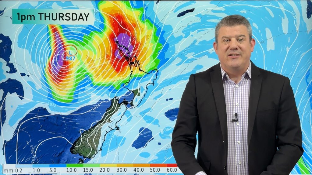
Thursday sees a cold front crossing NZ, possibly not until night time in parts of the North Island, bringing widespread rain and showers for a time. Rain is expected in many dry regions – but not all. Snow levels lower in the South Island but looks to remain above most main centres.
Friday sees rain easing in the upper North Island and slowly clearing over other parts of the north during the day, but it will remain unsettled and wet in many other places as the low near West Coast deepens further continuing rain and snow in the south. At this early stage serious snow looks to be above most main centres but it’s marginal. The placement of the low pressure zone is key. For it to bring serious snow to sea level across the South Island the low pressure zone should be east to south-east of the South Island… at this stage it’s forecast to be north-west of the South Island and that tilts the coldest air into the Tasman Sea area. This forecast may still change.
All of our local forecasts automatically update the weather symbol if snow is highly likely for your location.
All WeatherWatch.co.nz and RuralWeather.co.nz forecasts update every hour and auto-display any local official MetService watches and warnings.
The modelling for this event may still change, so please keep up to date with your local WeatherWatch forecasts and MetService warnings or watches.
Driest areas this week will be the east of both islands, especially the eastern South Island.
Wettest will be the west of both islands, especially the western South Island.
Coldest weather will be in the southern half of the South Island.
Mildest weather in the north and north east of the North Island.
Despite the messy nature of the storm developing later this week, for now the worst of the weather appears to be over the Tasman Sea. We’ll have more details in our video around lunchtime Monday about severe and general weather risks this week across New Zealand. This is a developing event.
Track latest MetService Severe Warnings & Watches here.


- WeatherWatch.co.nz
Comments
Before you add a new comment, take note this story was published on 9 Jun 2024.
Latest Video
Tropical low to bring wind & rain this week
A low exiting the tropics near New Caledonia this week will grow larger in the Tasman Sea and finally bring…
Related Articles
Tropical low to bring wind & rain this week
A low exiting the tropics near New Caledonia this week will grow larger in the Tasman Sea and finally bring…

High pressure grows, but a stormy end to next week possible
A settled weekend is on the way and apart from a few isolated showers in both main islands many regions…

A tropical low next week *might* affect NZ
It’s not locked in yet, but a tropical storm may end up drifting southwards towards NZ about one week from…


Add new comment