Mild weekend but wintry Monday in the south, we track the latest on the cold & snow (+6 Maps)
21/09/2018 10:27pm

> From the WeatherWatch archives
We have the latest snow forecast maps as a polar change hits southern New Zealand for the start of the working week but before it arrives many regions will enjoy mild weather, although in the north Saturday is kicking off a bit gloomy.
A weak low is situated off the northeastern coast of the North Island today and a broad area of light/broken rain is lying over the upper North Island. This area of rain will gradually retreat northwards during Saturday morning and afternoon and will continue to fall apart with increasing dry areas. Low clouds may remain until Sunday in some areas but sunny spells should develop later today for some in the north of the country.
On Saturday, most areas in the South Island and the lower North Island will be sunny with almost no clouds. Daytime temperatures are considerably higher than normal.
On Sunday it will again be sunny except the lower South Island will be affected by the first of a number of cold fronts coming in over the days ahead. Cloud may linger around East Cape and Gisborne on Sunday too.
By Monday a cold change sweeps into the lower South Island and brings snow and winter conditions to some areas… although a little further north in Canterbury, apart from a wintry Monday, the rest of the working week looks mostly sunny and dry due to the general angle of the wind flow.
RETURN OF WINTER WEATHER TO THE LOWER SOUTH ISLAND:
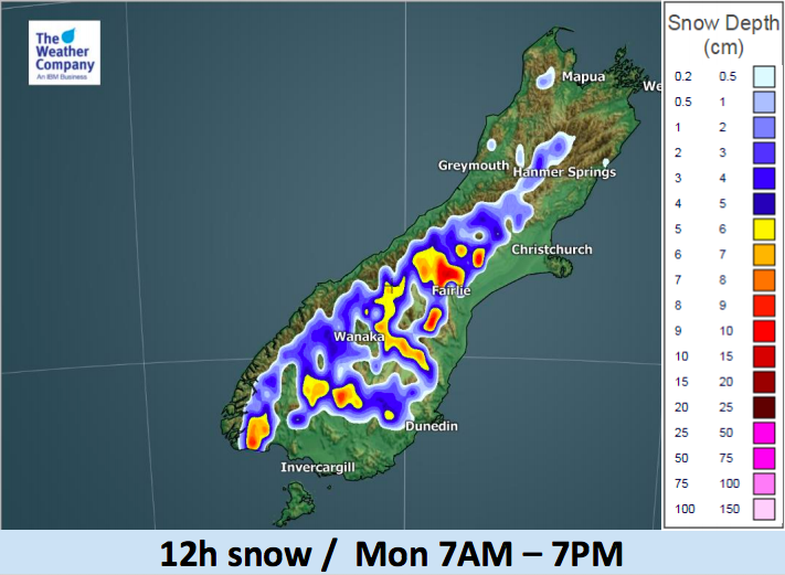
From Sunday night, rain and snow spreads up the South Island. Snow accumulation is expected in a wide area during the night. It will be mainly over the mountains and ranges but some snow or mixed precipitation may occur over the highlands and into some farming and growing communities. Alpine highways look likely to be affected.
As the low pressure brings colder air into the lower South Island there may be a chance for snow to fall lower than the maps indicate below. The maps below indicate where the bulk of the heaviest snow is likely. Downdrafts and certain valleys can produce lower levels of snow.
SOME GOOD NEWS:
As data and forecasts get more accurate as the event gets closer it does appear snow levels may be just a little higher than initially thought. It’s only a slight difference of about 1 or 2 degrees in air temperature but it may mean snow is a bit more borderline in most main centres, with any flurries looking short lived. Warmer soil temperatures will also melt snow faster. Many areas will be fairly dry north of Otago, this event is very much Southland, Otago, Fiordland, Westland and West Coast focused. Latest data suggests the airflow angles may help push an extra couple of degrees of warmth into the lower South Island than initially thought.
THE BAD NEWS:
This event, to us, has always been about warning of wind chill/misery index being fatal for newborn stock. Unfortunately the very slight lifting of the snow level will have only a slight impact on the misery index which looks to be fairly tough in exposed places next week due to a combination of cold southerlies, wet/wintry rain and showers and brisk winds at times. The feels like temperature will be below zero even in the day in some areas. There is also a chance of sea level snow falling in Fiordland, including Milford Sound – a heads up for anyone wanting to visit the area next week.
LAST BIT OF GOOD NEWS:
Got to end on a positive note and that is two fold. One, the lower South Island ski fields will get another boost from Mother Nature, helping to extend the season. Warmer winds also kick back in next week with Canterbury getting into the mid to late teens and double digit daytime highs returning to Southland, Otago etc.


– WeatherWatch.co.nz
Comments
Before you add a new comment, take note this story was published on 21 Sep 2018.


Add new comment