It’s too warm for this time of year, more warmer than average weather for Mon/Tue (+Maps)
10/06/2019 2:09am

> From the WeatherWatch archives
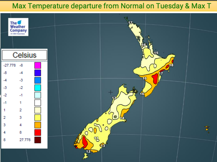
New Zealand has had two southerly blasts in 10 days and both only briefly brought in temperatures below normal. There’s a lack of frost and now both Monday and Tuesday are kicking off warmer than average nationwide.
High pressure just north of New Zealand is to blame, it’s pulling in a light westerly flow out of Australia and across NZ. Hardly wintry.
So far most of our weather this year has be influenced and dominated by very large highs coming out of Australia and pulling warmer air NZ’s way. We’re often asked if the lack of frosts and cold blasts this year, or the warmer than average trend, is climate change.
Climate change is measured in trends over decades and we can see that local weather patterns (just the placement of the highs and lows) are causing the warmer trends in the New Zealand area at the moment – but, when you look back at previous winters and autumns we do now have had a pattern of warmer than normal winters for the better part of this decade.
Also, at this stage there are no significant nationwide cold outbreaks forecast between now and the shortest day of the year, June 22 but we do expect more alpine snow and perhaps a few light frosts here and there in sheltered places.

– WeatherWatch.co.nz
Comments
Before you add a new comment, take note this story was published on 10 Jun 2019.
Latest Video

Spring-like until Christmas (NZ’s 11 Day forecast!)
Severe gales, heavy West Coast rain, and temperature fluctuations are on the way as spring weather returns following a much…
Related Articles
Spring-like until Christmas (NZ’s 11 Day forecast!)
Severe gales, heavy West Coast rain, and temperature fluctuations are on the way as spring weather returns following a much…

NZ: Spring gales, temp drops (& spikes) + Fiji has a tropical low to monitor
We have our first forecast for Christmas Eve & Day today, but this coming week looks spring-like as a colder…

Windy westerlies return next week + Vanuatu/Fiji tropical cyclone risk update
(No video Friday, next update is on Sunday) — NZ has a cooler/colder change coming in on Friday as a…


Add new comment