
> From the WeatherWatch archives
For several days in a row now long range computer models have been picking a tropical storm forming north of New Zealand in week two of March and moving towards the country in Week three.
With so many of you also noticing the various computer models and asking us about them we thought it was time to give a long range outlook for this potential tropical storm.
Directly north and northwest of New Zealand, over the Coral Sea (off the east coast of northern Queensland) and also over the Solomon Sea further north, lie the ideal conditions for making a tropical storm. It’s hot, it’s humid and sea surface temps are now at their highest.
The sea surface temperature in this tropical storm breeding ground is currently in the low 30s, compared to the air temperature over New Zealand at the moment which is only around 25 degrees generally (during the day) and sea surface temps around northern New Zealand at only around 20 degrees. This is important – as the cooler the air and sea temperatures around New Zealand, the weaker the storm would be as it moved our way.
So will it move our way?
Computer models all agree a low is likely to form into a storm between Queensland (to the west) and Fiji (to the east) – and this is likely to happen next week.
As we head past March 14th the low may well drop south towards New Zealand – but with a very large high between Tasmania and Fiordland the conditions aren’t perfect for a direct hit.
The ideal set up would be for the storm to lose its winds – but not the soaking rains – and then move into the upper and eastern North Island. It’s too early to know if this will happen yet.
This high in the south Tasman Sea is likely to try and nudge the tropical low to the north east of the country during the third week of March.
The low will naturally be trying to track south towards northern New Zealand.
Please note – this is a very early heads up and the low may not reach us – but there’s enough evidence now in the computer models to suggest it’s possible.
We’ll keep you updated on this potential tropical storm and any likely tracking.
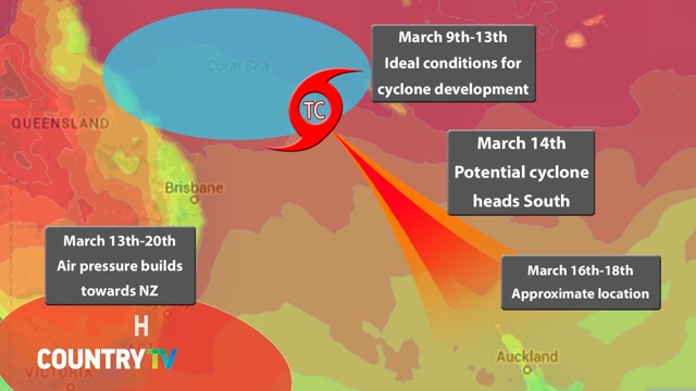
– Graphic / Kimi Knight, CountryTV/WeatherWatch.co.nz
– WeatherWatch.co.nz exclusive
Comments
Before you add a new comment, take note this story was published on 4 Mar 2015.
Latest Video

High pressure grows, but a stormy end to next week possible
A settled weekend is on the way and apart from a few isolated showers in both main islands many regions…
Related Articles
High pressure grows, but a stormy end to next week possible
A settled weekend is on the way and apart from a few isolated showers in both main islands many regions…

A tropical low next week *might* affect NZ
It’s not locked in yet, but a tropical storm may end up drifting southwards towards NZ about one week from…
NZ 9 Day: Two subtropical lows, but a lot of dry weather
In our extended outlook today we track two subtropical storms, one that will likely miss most of NZ while the…


Add new comment
Guest on 6/03/2015 4:30am
Just took a look (on Fri 6th March) – at the MetVUW thumbnail maps for NZ on March 15/16 .. wow, pretty impressive looking weather system predicted to approach from the North !
MetVUW maps seem to suggest some very low hPa readings coming across the North Island with this possible ex tropical cyclone. hPa readings of 960 – 975 ?! Hope that doesn’t come to pass .. there would be some significant wind damage, particularly around the eastern coasts of the North Island, with a storm that strong. Another Cyclone Bola, perhaps ? Guess wind strength will also depend on any pressure “squash zone” with high pressue to SW or SE of NZ, magnifying the gales or not. What are your thoughts on these maps, this far out ?
cheers Peter.
Reply
hitadmin on 6/03/2015 4:45am
Hi Peter – take a look at our latest weather video – I go into quite a bit of detail at the end about the cyclone and what is likely to happen as it moves in towards northern New Zealand and the various outcomes. It will be falling apart when it reaches NZ, but too early to know in what way – or exactly where – or if it will impact land or just out at sea. Things will start to come together a bit after the weekend once it’s formed.
– Phil
Reply
sm4rtboy on 5/03/2015 5:44am
Based on the latest models the cyclone is now forecast to head towards NZ but there are a lot of variation
Reply
Michele Laurie on 5/03/2015 12:17am
Hi Phil – If you could just keep it at bay till after Domain Day, that would be great! Last year Cyclone Lusi turned up uninvited to our day and we shifted the whole event to the racecourse! We woul love to have it in the Domain this year:)
Reply
hitadmin on 5/03/2015 12:20am
Saturday 14th looks calm, Sunday 15th looks mostly calm but easterlies building ahead of that potential tropical low. Gales possible on the Tuesday based on current models…so you may just get that calm sunny window! 🙂
Cheers
Phil
Reply
Guest on 4/03/2015 9:23am
It’s at exactly the same time as Lusi was last March. I attended a function 2nd weekend in March in the far north, where Lusi was ferocious. Maybe a repeat performance this year
Reply
Dave on 3/03/2015 11:52pm
Hi Phil
It would be great if you could track it give some advice on it. I am interested to see latest modelling maybe having it for further east than the pictures above.
I think that would eliminate Queensland & leave a Southerly or SE track as more likely. I guess it will basically come down to a race between the high & cyclone to reach NZ first. Whichever one wins that will determine the effects for us.
It will be very intriguing
Cheers Dave
Reply
hitadmin on 4/03/2015 12:01am
Hi Dave – yes you’re right about the modelling showing it further east (at least the blue area where it may form – this actually stretches from the Coral Sea to near Fiji). As for the tracking around NZ that’s the part that will change from day to day when you look at some computer models. The high south of NZ will certainly play a part too – either guiding the low east of NZ – or – holding it up around northern NZ. Still a very long way out – and there are about 5 scenarios, all quite varied!
Phil
Reply