Wintry snap coming next week + 7 day Rain & Snow Maps
26/07/2019 10:05pm

> From the WeatherWatch archives
It may be much warmer than average by day at the moment but a wintry snap is coming next week with much lower temperatures and snow.
The wintry southerly won’t last too long but will remind New Zealanders we are right now in the very depths of winter with historically the coldest weather between mid July and mid August. The cold snap next week is timed for July 31 and August 1st.
Temperatures To Drop
Snow will be heavy in the mountains and ranges of the South Island but it’s the drop in temperatures that will be more widespread than snow at this stage. No one escapes the temperature tumble next week, although the so called ‘winterless north’ only drops by a few degrees compared to several digit drops in the South Island. Despite the big drop in temperatures for some places most will only be dropping back to normal – as they are so much warmer than normal now.
For the most part the South Island sees daytime temperatures tumble by 4 to 9 degrees from this weekend/early next week to later next week when the cold change arrives.
In the North Island most places get 3 to 6 degrees shaved off your daytime highs around next Thursday and Friday.
Snow and Rain
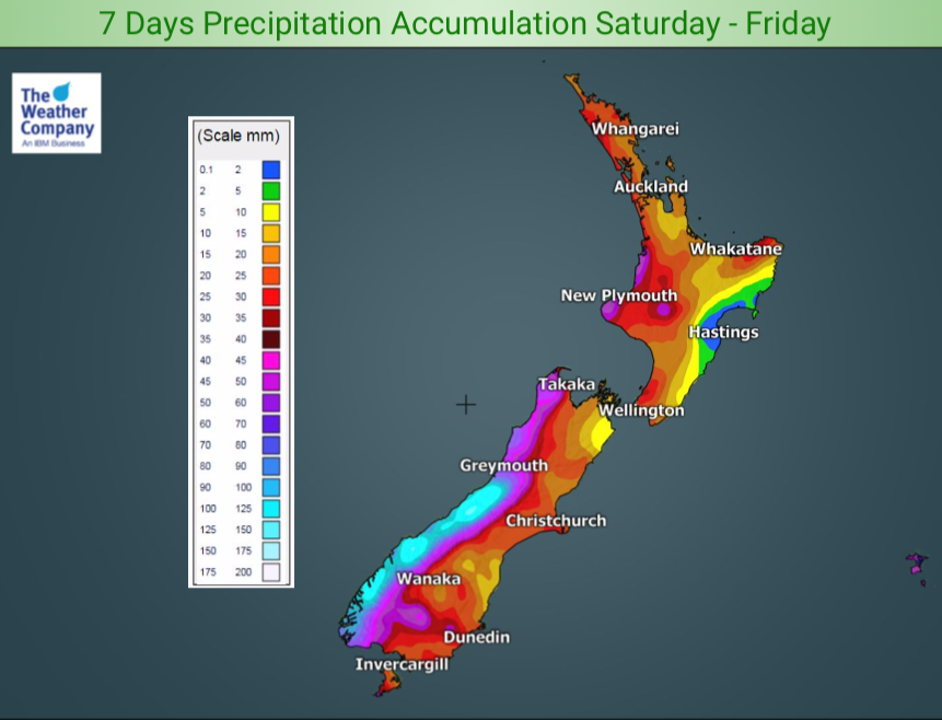
Heavy snow comes back to the Southern Alps but as for main centres this cold snap doesn’t look major, with only Queenstown, Te Anau and Wanaka perhaps seeing a few flurries (which may or may not settle). Wanaka and Cromwell have a low chance of some snow – or a high chance of it falling nearby. Elsewhere and to lower levels rain or sleet is more likely. On the tops of the Southern Alps over a metre of snow may fall while on the West Coast over 120mm of rain is possible. Lower totals are expected in the east of both islands.
Short Lived
This won’t be a prolonged cold snap. Westerlies kick back in within 48 hours to many places. Coldest air will likely linger late next week and into next weekend for most places but with the westerly change the freezing/snow levels will lift.
 – Next Wednesday, July 31, shows the polar southerly coming in. It’s from near Antarctica but isn’t quite an Antarctic blast. Map by MetOcean/GFS.


– WeatherWatch.co.nz
Comments
Before you add a new comment, take note this story was published on 26 Jul 2019.


Add new comment