Winter Outlook: June to be colder with a pattern of more big highs & big lows
6/06/2017 12:19am

> From the WeatherWatch archives
The pattern of large highs and large lows crossing the New Zealand area continues as we head through June with WeatherWatch.co.nz forecasting colder air flows this month and a continuation of the “neutral” pattern we’ve been in since about February.
June has kicked off cold and while some warm spots the general air flow across the country is colder across this week too.
A large low this weekend may drag in a cold, snowy, southerly especially for the South Island mountains and ranges – but it may also produce some briefly warm weather ahead of it.
This time next week and another very large high from southern Australia will be drifting towards New Zealand.
Next week’s high may bring in more westerlies and may not be overly cold – not as cold as this week by the looks of it.
There’s a chance that next weekend (11 days from now) may see yet another large low crossing the country with long term modelling indicating an even larger high rolling in for Week 3 of June, perhaps bringing more nationwide frosts.
This pattern of large high then large low is creating wetter than average patterns but also plenty of days to drain that rain away.
JUNE IN A NUTSHELL:
Our feeling is that June will be colder than a year ago with weekly rain events still impacting western and northern areas in particular but also plenty of dry and frosty days coming this month for the nation too as these large highs streaming in from southern Australia and the Indian Ocean continue to track our way. Plenty of air flows from the Southerly and Westerly quarters too.
WHAT ABOUT THE REST OF WINTER?
Well we’re not fans at all of seasonal forecasting in New Zealand unless we have a very strong pattern. Even last year Government forecasters confidently predicted a wetter winter for drought stricken Canterbury – which never eventuated, as an example.
Currently New Zealand is in a neutral pattern meaning anything can happen (Think about late Autumn, we had an out of season ex-cyclone then a week later an Antarctic blast). There is growing chatter in the global scientific community that hints at El Nino coming later this year. If this is the case we need to then find out if it will be weak, moderate or strong as a “weak” El Nino (which is measured at the Equator) may not impact New Zealand much and mean our ‘neutral chaotic’ pattern continues through winter and into Spring. This past summer Government forecasters said a “weak” La Nina would impact our summer – it never did, it was simply too weak to impact the weather this far south. So the strength of any future El Nino is critical to working out how it might impact New Zealand over the coming spring or summer.
While a chaotic/neutral season is harder to specifically forecast from week to week it does tend to bring in more variety to our weather pattern which, for most people, makes life a little easier as there are “breathing spaces’ between the ‘bigger events’. That’s our general outlook for June.

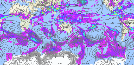
– June 19th – Note the pattern? Big highs and big lows streaming in from west to east, mostly south of Australia but directly impacting New Zealand as they track over us. This pattern looks very likely to remain with us until July at least, based on this map which extends right out to June 19th, about two weeks from today. / Weathermap.
– By head forecaster Philip Duncan, WeatherWatch.co.nz
Comments
Before you add a new comment, take note this story was published on 6 Jun 2017.


Add new comment