Will a Tropical Cyclone impact NZ early next week? It’s possible. (+5 Maps)
9/02/2016 7:52am

> From the WeatherWatch archives
It’s the third cyclone this season to come down our way – but this is the first one that may potentially make a direct hit with the upper North Island says WeatherWatch.co.nz.
The tropical low is expected to rapidly deepen into a Severe Tropical Storm north of New Zealand, near Vanuatu, towards the end of the week and weekend. It will then weaken somewhat as it comes towards New Zealand – but may still have dangerous weather with it.
“At this time of the year, over these incredibly warm sea waters north of New Zealand, this may well grow into a serious cyclone in the tropical South Pacific” says head weather analyst Philip Duncan.
Cyclone Pam hit Vanuatu in early March last year and was one of the worst storms in Vanuatu’s history.
Mr Duncan says there is a very large ‘pool’ of low pressure north of New Zealand at the moment with conditions “perfect for tropical cyclone formation”.
Fiji’s Met Service says there is a “low” risk of a cyclone forming today, a “moderate” risk on Wednesday, then a “high risk” by Thursday between Vanuatu and Fiji – with the low tracking southwards.
WeatherWatch.co.nz’s Philip Duncan says it’s too early to lock in what might specifically happen in New Zealand, but says the long range models do indicate northern New Zealand has a moderate risk of being directly impacted.
“It’s a bit tricky locking in the future track of a storm that is yet to even form, but latest data guidance suggests the centre of the low might cross the north east of the North Island – or perhaps just offshore from East Cape next Tuesday or Wednesday”.
Mr Duncan says it was too early to say if severe weather was expected in New Zealand from the tropical low. “We’ll need to wait until the end of this week to get a better idea on any possible severe weather here. The way cyclones form means the difference between fairly normal weather – and damaging cyclone weather – can be as little as a hundred kilometres, this makes long range precise forecasts of severe weather very tricky.
Confidence levels of wind and rain in northern New Zealand are about 40% as of today, which is what we class as ‘moderate confidence’ for a long range forecast.
WeatherWatch.co.nz will now have daily updates on this potential cyclone.
Don’t need to change your plans – but be aware of changeable forecasts!
This is simply an early heads up on the computer models and data – this is not a warning and if you have camping or travel plans coming up they do not need to be changed as we cannot predict if there will even be severe weather for New Zealand yet from this low. Check back over the coming days, though, as we get more details on whether a direct hit is possible – or if the low will weaken or track away from NZ.
MAPS:
GFS (American)
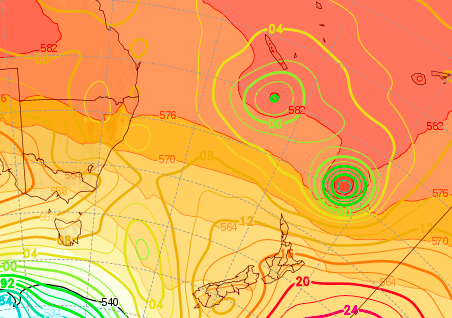
ECMWF (European)
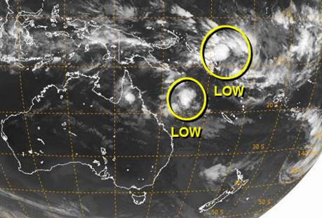
 Two areas of low pressure north of NZ – the one furthest north is the main area of concern / Image Joint Typhoon Warning Center.

High risk zone highlighted by the Fiji Meterological Service
 GFS Map for Sunday shows a tropical storm to the north of the country.

ECMWF map shows a low very close to the north east of NZ – but perhaps far enough offshore to keep severe weather out at sea. Definitely one to monitor over the coming days.

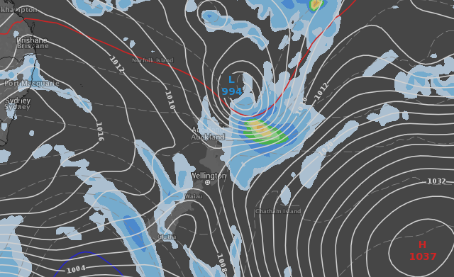
Wind and rain map for New Zealand around Monday/Tuesday next week via GFS & Weatherzone Australia
– WeatherWatch.co.nz
Comments
Before you add a new comment, take note this story was published on 9 Feb 2016.


Add new comment
Dave on 9/02/2016 7:54pm
Hi Guys
I look forward to your ongoing reports on this, potentially this could be very nasty for the NE of the country. Models seem uncertain at this stage of future tracking but there seems little doubt that at least one of the systems will be a cyclone if not both.
You are well ahead of the game in terms of warning about these systems which I am sure will result in more commercial success in the future.
Cheers Dave
Reply
Rick on 10/02/2016 12:06am
Hi Dave,
Your spot on as Weather Watch has the passion to protect New Zealnders and property.
Thanks to this site in the past I have been saved thousands of dollars!
Thank you for your fantasic work guys.
One of your loyal followers
Rick
Reply