Sunday Newsfeed: Updated snow & severe weather maps as brief polar blast moves closer (+8 Maps)
17/08/2024 11:55pm

> From the WeatherWatch archives
Severe gales, heavy rain, then a shot of polar air to drop temperatures with heavy snow. It’s a busy few days ahead weatherwise for many regions across New Zealand.
RAIN:
Rain remains on Sunday before the colder air arrives on Monday, turning rain to showers and/or snow and sleet. Hail showers are also highly likely.
GALES:
Generally speaking around the country winds are strongest Sunday and Monday.
SNOW:
From a cold air and snow perspective this starts on Sunday PM and peaks across Monday for the lower South Island, with coldest air reaching the North Island over Monday and into Tuesday AM.
Snow may be heavy above 200 to 400m for the lower South Island, with a possibility snow may even get down to sea level around Dunedin and other coastal parts of Otago down to the Catlins on Monday. Snow to sea level in NZ is often borderline but it’s certainly possible for a time with this set-up from about Dunedin southwards, in the south-easter corner of the South Island.
Late on Monday and into Tuesday snow will also affect the Central North Island, including State Highway 1 (The Desert Road).
TEMPERATURES:
Are above normal for many in the North Island today, but become below normal for most places over the next 24 to 48 hours nationwide.

- Wind chill, peak winds, temperatures, rainfall (see www.RuralWeather.co.nz or look under “Trends” in our app.
- MetService warnings and watches
- Cumulative rainfall maps for 7 days
- Maps and radar page
- Our free app and alerting app (main app is entirely FREE. Paid alerting allows you to set your own criteria at multiple locations for push alerts, including official MetService warnings & watches pushed to your device(s) for multiple locations for $6.99 a month).
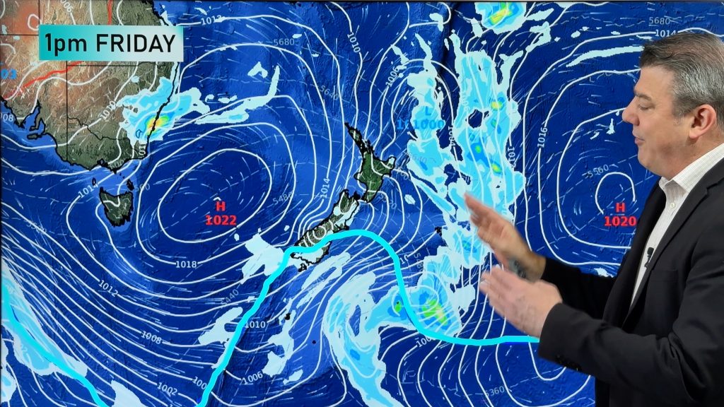
Sunday:
Brisk to severe gale north-westerly winds blow over the North Island with wind warnings likely in the north and east. Rain sets in over the top half of the South Island thanks to a weak area of low pressure. This could be good news for the northern half of Canterbury which is drier than usual for this time of year. But snow may lower in north Canterbury for a time as cold air meets that rain. Polar air arrives in the lower South Island later with snow levels lowering across the island by night time. Elsewhere rain or frequent showers will be passing through.
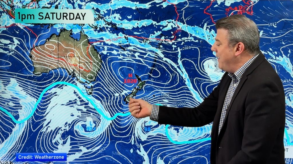
Monday:
A rough day for a number of regions. Snow to sea level is possible in parts of Otago and maybe the eastern side of Southland. Dunedin has a chance of snow to sea level for a time. Further north snow to sea level is less likely. This system is very cold and therefore lacks some moisture, and if winds shift more south-west that will keep more of Canterbury dry. The polar air is also short lived, gone by night time for most.
Snow flurries move into the North Island ranges, mountains and Central Plateau on either Monday PM or Tuesday AM.
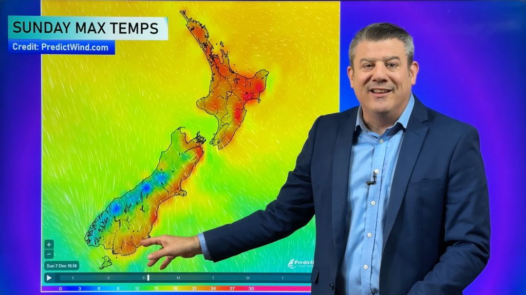
MAX temperatures on Monday from Dunedin to Queenstown will be only around +4 to 0 degrees. Wind chill for livestock will be below zero for over 24 hours.


- WeatherWatch.co.nz / RuralWeather.co.nz / Alerting App
- NZ’s most accurate weather data and more computing power (by far) than any other NZ forecaster.
Comments
Before you add a new comment, take note this story was published on 17 Aug 2024.
Latest Video
A few temperature swings, a subtropical low & subantarctic airflows
High pressure dominates much of NZ to kick off this week – and likely returns again this weekend – but…
Related Articles
A few temperature swings, a subtropical low & subantarctic airflows
High pressure dominates much of NZ to kick off this week – and likely returns again this weekend – but…
Hot & dry for many + Tropical Cyclone potential next week near Solomons/Vanuatu
The first tropical cyclone of the South Pacific Cyclone season may be forming next week well north of NZ with…
Drier weather returning, warmer too + some tropical trouble brewing
High pressure is moving closer to NZ today, pushing away yesterday’s downpours and thunderstorms well offshore east of the country,…


Add new comment
Geoff on 18/08/2024 4:21am
Great weather forecast thanks, bettering our Aussie services in many ways! (;-)
Quick question please as we’re flying into Queenstown Monday pm and staying in Wanaka – for some skiing.
The snow map indicates that Wanaka & region, might be somewhat sheltered from the worst of the gales and heavier snowfalls.
Is that likely or is it subject to change overnight into Monday?
Thanks – looks like a fresh top-up for the Southen Lakes snowfields?
Reply
WW Forecast Team on 18/08/2024 4:41am
Hi Geoff, thanks for the kind words. It may change but yes, for now those places look outside the worst. Biggest issue with flying into Queenstown will be visibility/sky conditions/cloud level more than anything else. And yes, all ski fields in NZ get some snow from this – even if not a huge amount they get some, followed by a couple of big frosty nights.
– Cheers
WW
Reply
Geoff on 18/08/2024 12:01pm
Thanks a lot WW! (:-)
Reply
Simon on 18/08/2024 1:00am
The thing I don’t get is your snow map shows its very likely to snow in Lumsden and up through Athol to Garson yet Metservice has such a little amount of rain on the way for the area that it would be next to nothing if it does snow.
Reply
WW Forecast Team on 18/08/2024 1:57am
Hi Simon, the data we have at WeatherWatch or RuralWeather for those locations will show you precipitation totals (updates hourly) and temperatures, and shows snow likely (or very nearby). Snow – just like rain – can be patchy with our hills/ranges so totals in some areas may be less/ or none, and others getting even more depending on elevation and exposure. For most locations that have snow possible, it doesn’t appear to be large amounts from this system which lacks some moisture (although worth noting even a light dusting can cause travel disruption and the lower the snow gets the more people it affects).
– WW
Reply
jet on 17/08/2024 11:38pm
is it poss nelson city might get sleet from this?
Reply
WW Forecast Team on 17/08/2024 11:49pm
Probably not sorry Jet. Air doesn’t look quite cold enough. But at midnight tonight/1am Monday it looks to be around 6 degrees with wet weather clearing, that’s about as close as it gets. About 4 or 5 degrees too warm.
– WW
Reply
View more comments