Weather headlines (x3) for Tuesday: Heavy rain West Coast, Strong northwesterlies, Rain in the east late Saturday
1/08/2022 7:00pm

> From the WeatherWatch archives
Here’s what is making the weather headlines today.
HEAVY RAIN WEST COAST TODAY
A front pushes northwards over the South Island today and with it comes some heavy rain with possible thunderstorms for the West Coast. Heavy rain about Fiordland this morning reaches Greymouth around midday then Buller this evening.
For more details on today’s warnings and watches from Metservice regarding rain please visit this page here.
For today’s thunderstorm outlook from Metservice please visit this page here.
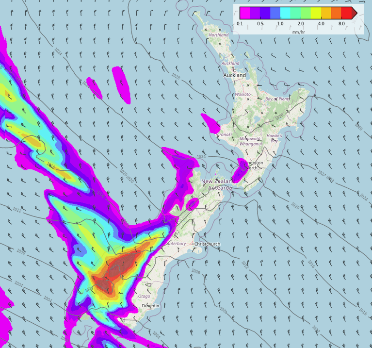
MSLP / Rain map – Tuesday 9am 
MSLP / Rain map – Tuesday 3pm 
MSLP / Rain map – Tuesday 9pm 
STRONG NORTHWESTERLIES
Expect a strong northwesterly airflow for the South Island and lower North Island today with gales likely through the Main Divide and about most inland areas, gales may reach the east coast at times.
Cook Strait will likely see gale northwesterly winds. For more details on today’s watches and warnings from Metservice in regards to wind, please visit this page here.
Wind map – Tuesday 9am 
Wind map – Tuesday 3pm 
Wind map – Tuesday 9pm
DRY IN THE EAST TILL SATURDAY
The eastern South Island has pretty good weather this week, Later on Saturday it goes down hill again with rain moving in. The eastern North Island sees rain or showers move in Sunday or Monday.
Till then, enjoy!

Comments
Before you add a new comment, take note this story was published on 1 Aug 2022.
Latest Video

Spring-like until Christmas (NZ’s 11 Day forecast!)
Severe gales, heavy West Coast rain, and temperature fluctuations are on the way as spring weather returns following a much…
Related Articles
Spring-like until Christmas (NZ’s 11 Day forecast!)
Severe gales, heavy West Coast rain, and temperature fluctuations are on the way as spring weather returns following a much…

NZ: Spring gales, temp drops (& spikes) + Fiji has a tropical low to monitor
We have our first forecast for Christmas Eve & Day today, but this coming week looks spring-like as a colder…

Windy westerlies return next week + Vanuatu/Fiji tropical cyclone risk update
(No video Friday, next update is on Sunday) — NZ has a cooler/colder change coming in on Friday as a…


Add new comment