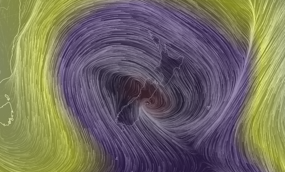
Very deep low centred near Banks Peninsula, heavy rain continues further south
21/07/2017 3:00am

> From the WeatherWatch archives
Updated 3pm — The very deep centre of the low crossing New Zealand now lies just east of Christchurch with weather stations around the area showing the air pressure is incredibly low. The air pressure is down to 964hPa in eastern Banks Peninsula while Christchurch is showing 970hPa. This compares to Auckland, which is 989hPa.
This steep pressure gradient is why it’s windy in many areas further away from the centre, like the sometimes gusty NW winds in the upper North Island and the strengthening SE winds in the lower South Island – all swirling around the very deep centre of this low centered just east of Christchurch.
Heavy rain continues to move south down Canterbury towards Otago and also into the mountains.
Rain is easing north of Timaru for now in coastal areas up to Christchurch – but becoming heavier in Dunedin and remains heavier further inland around the Canterbury region. The deep low means rain could regenerate again in places where it has eased. It’s a very deep and unstable system.
There is some flooding, highways closed – and more flooding is possible this afternoon. Some localised areas may have significant areas of flooding, especially in areas where drainage isn’t so fast.
WeatherWatch.co.nz expects the heaviest rain for Dunedin to be from about mid afternoon until early evening, before easing back to some degree overnight. Rain continues into Saturday too. See our detailed Dunedin and Christchurch forecasts for more (including hourly forecasts and % chance of rain)
Keep an eye on the Forecast Rain Radar to track the heaviest rain over the next 24 hours.
View our latest Video on this deep low and how it will affect the weekend’s weather.
 Image / Purple colouring shows low pressure, with the centre of the low near Banks Peninsula as of 2pm Friday / earth.nullschool.net
– WeatherWatch.co.nz
Comments
Before you add a new comment, take note this story was published on 21 Jul 2017.


Add new comment