> From the WeatherWatch archives
UPDATED 6:30pm, Friday
The latest from MetService on the thunderstorms moving in tonight and tomorrow.
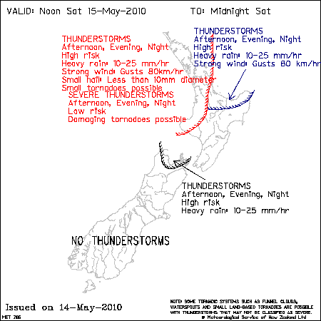
A large low pressure area covers the Tasman Sea and New Zealand, and bands of showers are moving across the country. There is a high risk of thunderstorms developing in Northland late morning, then spreading this afternoon to Auckland,northern Coromandel Peninsula, Waikato, Waitomo and Taranaki. The thunderstorms are likely to be accompanied by localised brief heavy rain, winds gusts to 80km/hr, and possible small tornados. There is also a low risk of a damaging tornado.
Chart BELOW amended for introduction of risk of severe thunderstorms.
The next band of heavy showers and thunderstorms will move onto the west of the North Island this evening and cross the upper North Island overnight and Saturday morning.
There is a moderate risk of one or two thunderstorms becoming severe over northern Northland later this evening. These may produce brief heavy rain, hail of 10-15mm possible damaging wind gusts of 110+km/hr and a possible small tornado about the northeast coast. Then over the rest of Northland and northern Auckland and extending down into north Taranaki, there is a moderate risk of thunderstorms developing by the end of the period giving localised brief heavy rain, small hail, wind gusts to 90km/hr, and possible small tornados.
There is now a moderate risk of thunderstorms in northwest Marlborough for a few more hours this evening.
A low risk of thunderstorms extends across into Bay of Plenty and Taupo, and down into north Westland, as indicated on the chart.
No thunderstorms or significant convection expected elsewhere.
.gif)
.gif)
The low starts to move southeastwards towards central New Zealand from Saturday afternoon. Further bands of showers and rain are expected to spread across northern and central New Zealand. The high risk of thunderstorms persists in the northwest of the North Island as before, with still a low risk of damaging tornados. There are likely to be further heavy thundery falls in the Bay of Plenty. In Nelson and northern Marlborough, the high risk of thunderstorms continues.The likelihood of heavy rain increases in this area, while the risk of hail and small tornados diminishes.

– MetService/NZ Govt
Comments
Before you add a new comment, take note this story was published on 14 May 2010.


Add new comment
Phil Smith, Levin on 14/05/2010 6:35am
Hi Phil, do you think Levin could get a thunderstorm, its so long overdue. The weather started to change around 4pm. Well fingers crossed.
Reply
WW Forecast Team on 14/05/2010 9:17am
Not tonight.. if you saw the basic graphic we did ealier today, of the yellow circle outlining the low’s energy, it only brushed the Far North and Taranaki. It will move eastwards tonight and tomorrow… but you’re not in the best positive as the activity is coming from the north.
I wouldn’t completely rule it out, as we have an almost 100% confidence for Taranaki (90%) so you may well see lightning at the very least – either tonight or tomorrow night.
Let us know how things go
– WeatherWatch
Reply
BQ on 14/05/2010 4:46am
In the space of just one hour Auckland’s mod has changed dramatically.
At 3pm fine, clear and sunny with a moderate breeze.
At 4pm the Atmosphere feels angry, glooming and stirring.
There is quite an evident line where this system is “curving” around as depicted on the satellite maps. It’s almost dividing the city in two!
Reply
GuestPaul on 14/05/2010 5:04am
Squall line passed over Puhipuhi at 4pm,quite intense with lightning, 5 mls rain,gusts but only about two kilometres wide with tops going to 25000 feet.Typical fast moving winter type squall.
Reply