Unusual Cyclone Owen now ‘severe’, flooding for Australia likely but storm unlikely to directly affect NZ (+6 Maps)
13/12/2018 10:25pm

> From the WeatherWatch archives
Cyclone Owen is now a Severe Category 3 Tropical Cyclone and Australian forecasters say it may peak at Category 4 today before making landfall in northern Australia and then sliding down the Queensland coast as a significant rain event.
Owen is one of only a few storms in history to take this unusual track. Owen has also been named a Tropical Cyclone twice after initially forming on December 3rd in the Solomon Sea, then weakened back to a Tropical Depression in the Coral Sea before moving westwards over northern Australia only to reform in recent days.
Today Owen has roared into life and is stronger than ever. The storm has started to backtrack and this weekend will take the unusual track SE down Queensland, hugging the coastline and bringing big rainfall totals. It may lose cyclone status over land though, as they usually do, however Aussie forecasters are even suggesting it may hover around Cat 1 even over land. Once Owen reaches southern Queensland the low itself should fall apart very quickly.
WILL OWEN HIT NEW ZEALAND?
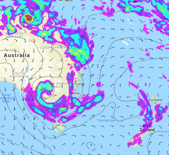
No, not based on reliable modelling which shows a large high in the New Zealand and Tasman Sea areas will stop Owen in his tracks. The left over moisture and tropical warmth from Owen may linger around the Brisbane area until around Christmas. The leftovers may then start to drift out over the Tasman Sea – but there’s a lot of uncertainty about this. Either way, the storm that is Owen today doesn’t look likely to affect New Zealand. It will remain ‘one to monitor’ until even the leftover downpours have finally moved on, probably some time around Christmas.
 – Weatherzone.com.au
 – JTWC
 – JTWC / Google Earth
OWEN’S TRACK FROM NORTHERN AUSSIE, TO QUEENSLAND before falling apart:
NOON FRIDAY (TODAY)
NOON SUNDAY:
NOON TUESDAY (Owen has fallen apart around Brisbane)
– Maps courtesy of MetOcean
– WeatherWatch.co.nz
Comments
Before you add a new comment, take note this story was published on 13 Dec 2018.


Add new comment