Tuesday Newsfeed: The latest on the large low developing this week, FAQs + 5 Maps
10/06/2024 9:59pm

> From the WeatherWatch archives
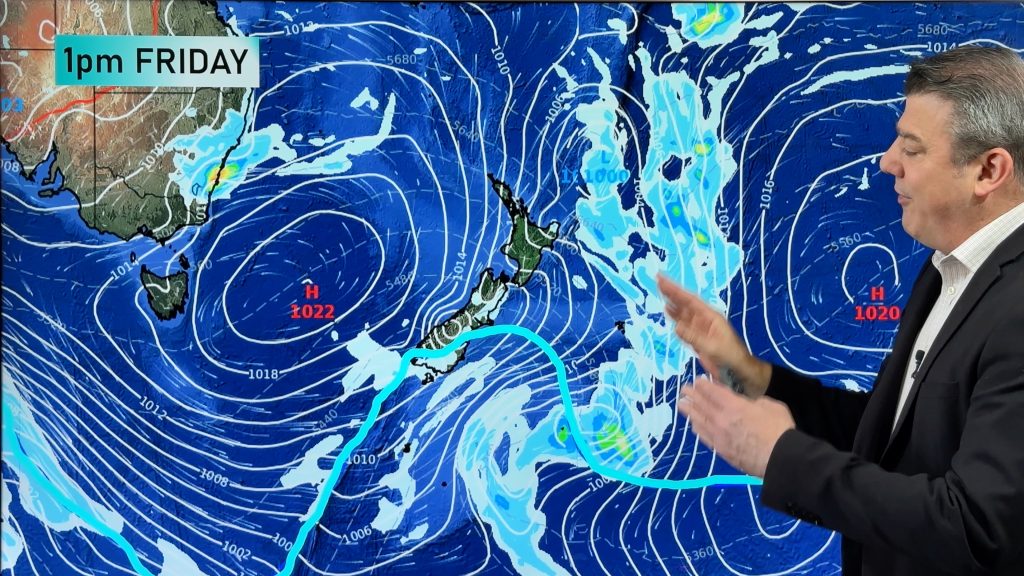
Low pressure means instability and instability makes precision harder. A large low will engulf the Tasman Sea region later this week and will cover all of New Zealand too.
Big doesn’t always mean bad – so while the low might look intimidating the severe risks aren’t widespread for everyone, but the instability means pockets of severe weather may be possible in many regions of both islands for a time.
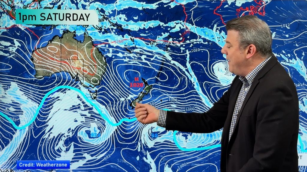
The low is likely to deepen on Thursday, Friday and Saturday offshore from NZ over the Tasman Sea, then weakens later this weekend as high pressure south of NZ sneaks in and begins to shut down, or ease, the Southern Ocean airflow feeding into this low.
FAQs
Is this a major snow event?
For the Southern Alps cold air mixing with sub-tropical moisture can produce very heavy snow. It’s too early to lock in how much will fall in the mountains because the shape and precise location of the low’s centre later this week hasn’t yet been determined. At this stage, this does not look like a major snow event for most places – but we must point out the cold air capable of doing this will be very near southern NZ (in other words, this is still something to monitor closely this week). For now, the bulk of the coldest air looks to be heading towards Tasmania and the central Tasman Sea – to the west of NZ. This may still change – this is not locked in yet.
Will snow fall to sea level?
Not at this stage.
Will snow fall in the main cities of the South Island?
No, not at this stage – it’s looking too mild by a few degrees. Queenstown is marginal for snow this weekend in the township, leaning towards rain at this stage.
It looks like a tropical cyclone or hurricane – is it the same?
While they can look similar – and are both low pressure zones – cold centred lows outside of the tropics (as opposed to warm centred tropical cyclones) means the wind energy is spread out over a greater distance and the rainbands are far more broken up and fractured. A tropical cyclone has all the wind energy at the centre but these colder lows can have much calmer centres and their windier weather can spread hundreds of kilometres from the centre, in a much more messy way. The centre of these lows are lazier and unstable and rain bands and thunderstorms can form suddenly even out of clear skies.
Why can’t forecasters be more specific about the risks yet?
Firstly, the low hasn’t even formed yet. Secondly, large lows like this can have gales on one side, calm on the other. Rain on one side, dry on the other. They can produce widespread areas of weather to monitor – from heavy rain, snow, gales and thunderstorms, but NZ’s mountains and ranges complicate the forecast further – so that’s why it takes time to lock in. A slight shift in a forecast airflow, from a south-easterly to a southerly may not seem like much on a nationwide weather map – but our mountains and ranges can mean that small shift is the difference between your area having snow or not, rain or not, gales or not etc. The forecast will become much clearer over the next few days.
Will everyone have severe weather?
No, based on modelling over the past few days severe weather looks to be in many of the usual parts of NZ – ie, mountains, ranges and exposed areas and some other more populated areas may also be exposed – that’s the part we can’t lock in this far out due to the nature of this low. The closer the centre gets to NZ the more instability there is and the higher risk of pockets of severe weather.
Which areas are most at risk?
It’s too early to be precise about this – as the low is forming in an unpredictable way, which is seeing daily modelling updates shift around. The best way to monitor it is using our forecasts which update all your hyper-local data every single hour. That on top of MetService watches and warnings (which may not appear for a few more days) and our daily weather videos should help you make sense of all the information already out there. There will be large dry areas in the mix too.
Will travel plans be affected?
Yes, highways and flights may be impacted by weather conditions later this week and weekend due to this low. Please note, most airlines and pilots make the decision to fly or not around the time of departure. Questions about flights are not something we can answer outside of general weather risks.


- WeatherWatch.co.nz
- New Alerting App – Get fewer nasty surprises. Set your own criteria for multiple alerts over multiple locations, including push notifications for MetService warnings across multiple regions. $6.99 for alerts. Or, try the FREE version – it’s still NZ’s largest weather data app!
Comments
Before you add a new comment, take note this story was published on 10 Jun 2024.
Latest Video
A few temperature swings, a subtropical low & subantarctic airflows
High pressure dominates much of NZ to kick off this week – and likely returns again this weekend – but…
Related Articles
A few temperature swings, a subtropical low & subantarctic airflows
High pressure dominates much of NZ to kick off this week – and likely returns again this weekend – but…
Hot & dry for many + Tropical Cyclone potential next week near Solomons/Vanuatu
The first tropical cyclone of the South Pacific Cyclone season may be forming next week well north of NZ with…
Drier weather returning, warmer too + some tropical trouble brewing
High pressure is moving closer to NZ today, pushing away yesterday’s downpours and thunderstorms well offshore east of the country,…


Add new comment