Tuesday Newsfeed: Cold front, then high pressure, then bigger cold front, then more high pressure…
23/09/2024 4:00pm

> From the WeatherWatch archives
A windier south-west change moves up NZ today with marine gales and a drop in temperatures to the lower South Island. Spring weather carries on across the country.
((Our next monthly ClimateWatch outlook will be issued next Wednesday, October 2nd))
Let’s get into the forecast for Tuesday…
RAIN:
The south-west lean to the weather today means that the Deep South and western NZ are most exposed to wet weather – although only low rainfall totals for the western North Island. The east is dry or mainly dry – can’t rule out a brief shower. Keep an eye on the rain radar if rain matters to you today.
WIND:
South-West winds are strong in exposed parts of the country today – in true spring fashion. Some parts of the eastern North Island may have more of a west to north-west lean for a time.
TEMPERATURES:
Temperatures are down today for the lower South Island, with Southland and Otago most exposed to the cold air – this moves further into Canterbury tomorrow. Northern and eastern parts of the North Island are milder than average today with temperatures possibly in the low to mid 20s for places like Hawke’s Bay.
DAYS AHEAD:
Wednesday’s forecast may be more pleasing to many people as high pressure finally moves closer to the country and this pushes most of the windy weather out east of New Zealand – it also brings a milder nor-wester back to the lower South Island, lifting temperatures. Most places are dry – and any showers look short lived and fairly isolated.
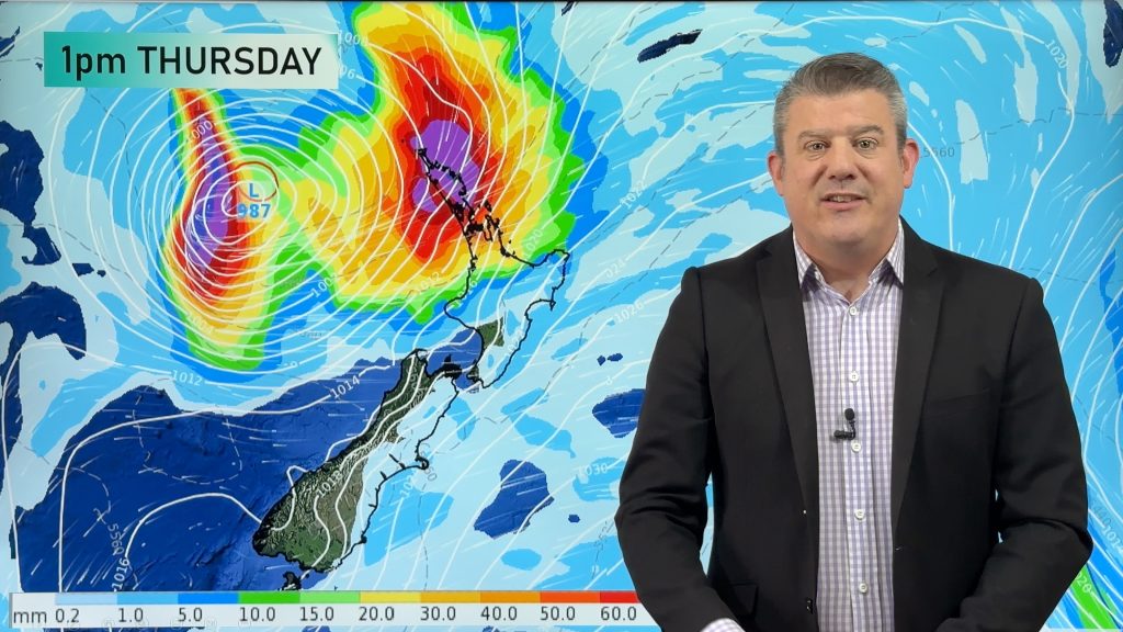
On Thursday the high remains over northern NZ while a large cold front and areas of low pressure move into the south-west corner of the South Island with heavy rain and strong winds. Later on Thursday and going into Friday that rain falls as snow along the Southern Alps and rain heads northwards into the North Island.
That active cold front moves into the North Island on Friday with a wintry change behind it for large parts of the South Island.
High pressure expands going into this weekend – reducing wet weather and increasing frost risks around the South Island’s interior.


As always drill down deeper with your hyper-local, hourly, 10 day forecasts at WeatherWatch.co.nz – or download our Free WeatherWatch App.
Comments
Before you add a new comment, take note this story was published on 23 Sep 2024.
Latest Video
Tropical low to bring wind & rain this week
A low exiting the tropics near New Caledonia this week will grow larger in the Tasman Sea and finally bring…
Related Articles
Tropical low to bring wind & rain this week
A low exiting the tropics near New Caledonia this week will grow larger in the Tasman Sea and finally bring…

High pressure grows, but a stormy end to next week possible
A settled weekend is on the way and apart from a few isolated showers in both main islands many regions…

A tropical low next week *might* affect NZ
It’s not locked in yet, but a tropical storm may end up drifting southwards towards NZ about one week from…


Add new comment