Thursday Newsfeed: Those spring westerlies kick back in again …
18/09/2024 4:00pm

> From the WeatherWatch archives
Spring westerlies come back to life again today across many parts of the country due to high pressure north of New Zealand and very large and deep storms over the Southern Ocean. This very low air pressure south of NZ combined with the high pressure north of us is fuelling the westerly winds.
Let’s get into the forecast for Thursday…
RAIN:
The direction of the airflow into New Zealand today means the western side of the North Island is exposed to showers with rain setting in to the West Coast – a few showers will also make it into Southland. Snow will fall again on the Southern Alps, especially to the south. Eastern areas across much of the country will remain dry or mainly dry.
WIND:
West to North-West winds will blow across much of the country with stronger winds through central NZ, the southern Alps, and to those parts of the North Island most exposed to westerly winds. Check your WeatherWatch local forecast if you’re unsure.
TEMPERATURES:
Westerlies across the country bring a fairly classic temperature spread for NZ today, with mildest weather in the north and east of both islands and coolest weather in the south of the South Island. Despite a colder pool of air over the lower south-west corner of the South Island today, many places are either back to average, or even milder than normal for mid September.
DAYS AHEAD:
Friday is similar to Thursday with westerlies bringing western rain and showers, spreading across the North Island, but most eastern places stay dry or mainly dry.
Saturday has west to north-west winds which are milder in the North Island. Those nor’westers pick up in the lower South Island. Mainly places are dry or mainly dry on Saturday, wet weather is most likely around Fiordland and south Westland.
On Sunday the north-west wind flow picks up a notch, another surge of wet weather moves in from the Tasman Sea to western NZ – as showers for many places, and rain is more likely again around Fiordland. Eastern areas are again dry for the most part.


As always drill down deeper with your hyper-local, hourly, 10 day forecasts at WeatherWatch.co.nz – or download our Free WeatherWatch App.
Comments
Before you add a new comment, take note this story was published on 18 Sep 2024.
Latest Video
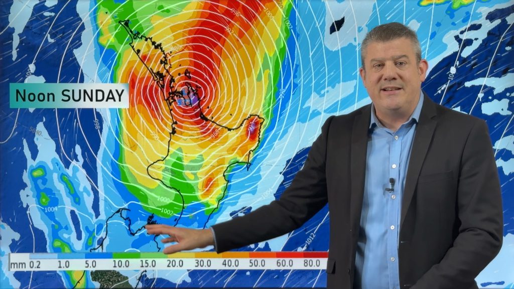
NZ (THU): Latest on Cyclone Vaianu, Sunday landfall in North Island
Severe weather is expected to develop as early as Saturday in the upper North Island ahead of Cyclone Vaianu, which…
Related Articles
NZ (THU): Latest on Cyclone Vaianu, Sunday landfall in North Island
Severe weather is expected to develop as early as Saturday in the upper North Island ahead of Cyclone Vaianu, which…

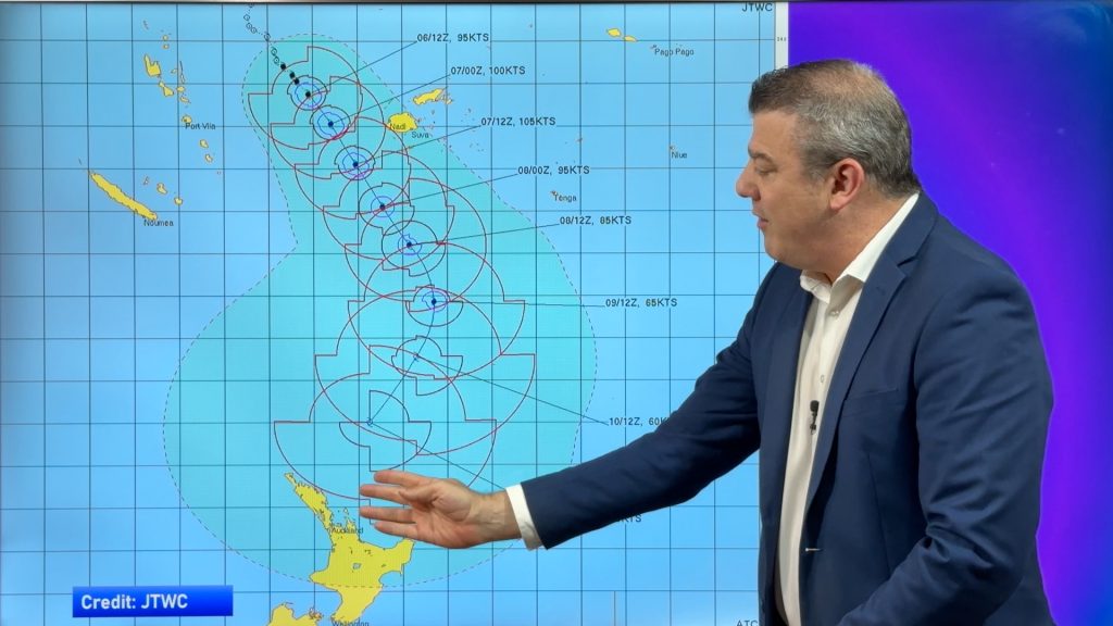
Tropical Cyclone Vaianu’s track directly into NZ this weekend
Localised heavy rain is still affecting some parts of NZ today, seperate to the tropical cyclone which is tracking directly…
Tropical Cyclone VAIANU: Fiji then NZ
*Published Tuesday AM* Fiji is being affected today by offshore Severe Tropical Cyclone Vaianu and NZ has the chance of…


Add new comment