Thursday Newsfeed: Niwa to take over MetService (+5 Maps)
26/09/2024 1:57am

> From the WeatherWatch archives
Apologies, we have no video today – instead we’ll have both NZ and Australia video updates on Friday.
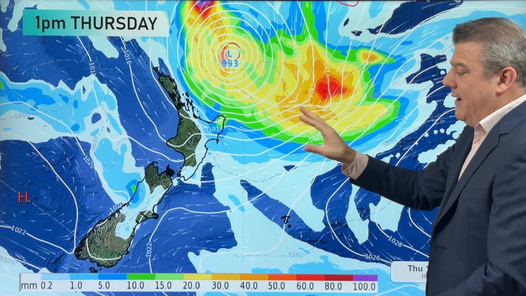
Just when you thought high pressure was rolling on in, it’s already rolling on out – but it will return again this weekend. In the meantime we have a classic spring cold front moving up NZ with a burst of wind, rain/showers and some southern snow.
See the live MetService warnings and watches map here.
In other news, Minister Judith Collins has today announced that Niwa will take over MetService. Full media release here.
Let’s get into the forecast for Thursday to begin with…
RAIN:
Heavy rain moves up the West Coast with heaviest falls south of Hokitika – and sorry Southland you get more wet weather spilling over today too. Some rain also spills over into Otago and possibly some will also make it over into Canterbury and Nelson at some point. There might be a shower elsewhere in NZ otherwise it’s dry – but that front moves into the North Island overnight and into Friday.
WIND:
Strong nor-westers blow over the lower North Island and upper half of the South Island with gales in exposed places, possibly severe gale for a time around central NZ. Winds ease after the front and tilt more south-west.
TEMPERATURES:
Sub-tropical and northerly flows for the North Island and upper/eastern South Island will keep many places warmer than average for this time of year today. But that colder shot of air for the lower South Island will set in later bringing snow to the mountains and ranges.
DAYS AHEAD:
That cold front moves up and over the North Island on Friday and clears northern NZ by the end of the day or night time. The front will weaken as it heads north with most places receiving less than 10mm. Check your local rainfall totals at WeatherWatch or RuralWeather to drill down deeper. Showers will also spread along the east of both main islands, won’t be much though. Showers also remain in Southland on Friday with more wintry airflows.
On Saturday high pressure moves closer to NZ from the Tasman Sea, encouraging a south-west wind over NZ, in typical spring fashion.
And by Sunday that high moves closer, but the windy sou-westers remain in some places along with a few isolated western showers – otherwise dry, especially in the east.


As always drill down deeper with your hyper-local, hourly, 10 day forecasts at WeatherWatch.co.nz – or download our Free WeatherWatch App.
Comments
Before you add a new comment, take note this story was published on 26 Sep 2024.
Latest Video
Subtropical low (yes, another one) to brush the NI, high pressure still in charge
A subtropical low will power up over the next 24 hours and brush past the north-eastern corner of the North…
Related Articles
Subtropical low (yes, another one) to brush the NI, high pressure still in charge
A subtropical low will power up over the next 24 hours and brush past the north-eastern corner of the North…
NZ weather: Skies will get drier before they get any wetter
High pressure is the main feature of New Zealand’s weather this week, the upcoming weekend and likely kicking off next…

NZ 8 Day: High pressure to return, also monitoring tropics next week
A cooler change is moving into NZ tonight and Saturday then winds ease further on Sunday as high pressure starts…


Add new comment