> From the WeatherWatch archives
It’s been with us since last Friday and as we head into Tuesday more severe weather is expected across a number of regions.
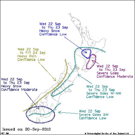
The government forecaster, MetService, is predicting a risk of more severe gales and heavy snow in both islands.
As the deep low from the weekend begins to move away other lows that normally circle around Antarctica are fuelling the windy, cold, weather over the lower South Island and driving strong to gale force winds over central regions of the country, roughly from Canterbury to Taranaki.
More snow is also expected around Southland and Otago and possibly the Desert Road.
But there is some good news – WeatherWatch.co.nz’s head weather analyst says the severe weather is increasingly becoming confined to places where it’s “more normal”.
“At this time of the year it’s not uncommon to see winds gusting to 130km/h at Castlepoint in Taranaki or winds on the Hauraki Gulf sustained at gale force. Over the next few days we will see the severe weather becoming confined to places where it’s more normal and less severe weather in our main centres” says Philip Duncan.
“Even the snow flurries and sleet in Southland should be more at a ‘normal’ level for September over the next couple of days”.
Mr Duncan says while more weather warnings are likely the worst of this severe weather event is behind us. “The worst was certainly on Friday and Saturday so we will gradually see things calming down over the rest of the working week. That shouldn’t detract from any warnings or watches though – they should still be taken seriously if you live in an affected region and especially those in Southland as snow events can change very quickly”.

Map courtesy NZ Govt
Homepage image: Snow in Invercargill at the weekend – Malcolm Gayfer
Comments
Before you add a new comment, take note this story was published on 20 Sep 2010.


Add new comment
Guest on 20/09/2010 10:26pm
Ok we have had enough of this crap please tell us that its going to get better and soon. I’m not likeling the look of metservices rainforcast maps for the next week.
Reply
David - New Brighton on 21/09/2010 12:26am
…we could always do a swap….say a couple of 3.5 mag aftershocks with, what you got….snow, perhaps ? 8 – D
Reply
sw on 21/09/2010 3:06am
Yes the only excitement we had here was a couple of hours on friday night of lightning and thunder,then again on the same night the big squall,other than that its been just the usual mix of showers and cloud with some wind from time to time and worthless sort of sun when it actually tried to shine.
Reply
David - New Brighton on 21/09/2010 4:29am
…well, SW ( is that west coast of N.I. – Wanganui to Waikato ? ), at least you did get a taste of something exciting, and for us, with our mainly sunny Canterbury skies and hard frosts the last 3 days, we actually got a bit of sleet today…and apparently a few people about town reckoned they even saw a couple of snow flake?….[ Well, I never 8 – ] ]
And, right now we have cumulonimbus incus mamma developing ( anvil tops hidden ) and quite a bit of virga out to the west ( ice/ snow falling and maybe reaching the ground ?..)
..that shower cloud heading up the S.I. right now ( ref satellite picture on weatherwatch home page could be interesting for us tonight perhaps ?
8 – ]
And for your enjoyment and edification, I give you the following:
Whether the weather be fine
Or whether the weather be not
Whether the weather be cold
Or weather the weather be hot
We’ll weather the weather
Whatever the weather
Whether we like it or not!
Reply
David - New Brighton on 21/09/2010 4:50am
…’whether the weather be hot’…….murphys’ law?
Reply