Temperatures to drop Friday to Monday, lift back up slowly next week (+3 Maps)
4/09/2019 1:39am

> From the WeatherWatch archives
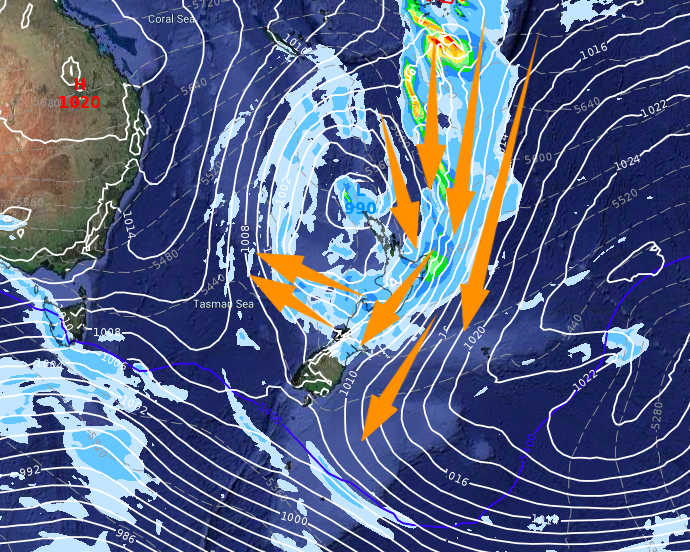
A sub-tropical low continues to affect NZ today bringing mild weather and more rain and northerlies, but cooler air is coming. As this low pulls away on Thursday it will help dredge up a colder southerly through until Saturday when it fades.
But it’s another low this weekend that has an even colder tail to it.
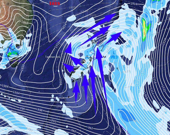
Another big low on Sunday moves in from the Tasman Sea and again brings sub-tropical mild northerly quarter winds for a time with rain – mostly for the North Island. This may see some places warm back up again for a time on Sunday in the north. At the same time as this low passes quickly over the North Island it helps work with a high south of NZ to dredge up a brief but cold southerly flow.
Incredibly, these cold snaps may not make huge parts of NZ colder than average, due to the weather being so much warmer than normal for the past week or two.
Check your local 10 day forecast and hourly temperatures, either at WeatherWatch.co.nz or our new website www.RuralWeather.co.nz – which has far more graphs and data showing rain and temperature trends coming up. This way you can get a clearer idea as to how much cooler it will get at your place.
High pressure should be expanding around the South Island on Sunday/Monday calming things down at the same time colder air is around – but there is the chance of a few brief low level snow flurries in the eastern South Island overnight Sunday and into Monday morning – a heads up to farmers with new born lambs more so due to the cold + damp. The good news is it will be short lived and any snow totals look incredibly low at lower levels, but the cold and damp air is certainly peaking Sunday night and Monday morning. Daytime highs look to be around 5 to 10 degrees over the South Island on Monday which isn’t too bad if not prolonged and not with strong winds.
Milder weather slowly returns across next week by the looks of the latest models, as the spring westerlies kick back in but expect the next several weeks to be changeable as they are very well known for being chaotic with temperatures going up and down like roller-coasters. Spring is all about winter slowly fading away – but hints of summer slowly coming in.
TODAY’S MILD SET UP:
THIS FRIDAY A COLDER CHANGE SPREADS UP THE COUNTRY FOR A TIME, RESETTING TEMPERATURES BACK TO NORMAL:
NEXT SUNDAY EVENING SHOWS ANOTHER LOW IN THE NORTH ISLAND, ANOTHER COLDER CHANGE IN THE SOUTH ISLAND WITH THE SOUTHERLY COMING IN FROM FURTHER AWAY (Coldest in the east)
– WeatherWatch.co.nz
Comments
Before you add a new comment, take note this story was published on 4 Sep 2019.


Add new comment