> From the WeatherWatch archives
Do you have photos of the cyclone in Fiji?
Send us your photos
11:30pm Mon: Severe Tropical Cyclone Tomas is now at its closest point to Vanua Levu, with the centre of the eye roughly 60kms offshore to the east.
WeatherWatch.co.nz says it will cause major damage to homes and infrastructure along the eastern coastline until dawn NZT and continue to cause major damage to the islands dotted south east of the mainland until at least Tuesday afternoon NZT.
The monster storm, which is more aggressive than Hurricane Katrina when it made landfall near New Orleans, is now tracking southwards which means it should now spare the main island of Fiji including the capital Suva and holiday resorts near Nadi.
WeatherWatch.co.nz’s head weather analyst Philip Duncan says the storm looks incredibly dangerous. “The eye of the cyclone is clear to see on the satellite maps. Tomas is an aggressive storm that is unfortunately very likely to cause widespread damage to the north eastern Fijian islands”
The strongest winds are gusting up to 270km/h.
Tomas is currently a weak Category 4 cyclone and overnight will most likely become a strong Category 3. “There is very little difference between a weak cat 4 and a strong cat 3. Either way this is a very serious tropical storm”.

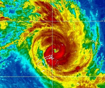
The eye of Cyclone Tomas can be clearly seen in this latest image. The two main islands of Fiji can be seen south west of the eye, outlined in white. Image / GOES NOAA
Tomas is moving very slowly which significantly increases the potential for serious flooding and wind damage.
WeatherWatch.co.nz this morning spoke to Newstalk ZB Account Manager Laura Noblejas currently holidaying near Nadi. “We’ve been told to pack our suitcases and be prepared to evacuate from our water front hotel tonight, most likely between 6 and 9pm”.
Newstalk ZB drive host Larry Williams interviewed Laura Noblejas just after 5pm NZT and she says it’s still quite sunny with only a light breeze. “Many shops including Westpac and ANZ have closed their branches while smaller businesses have moved stock to higher shelves in case of flooding. Some buildings have cyclone shutters and wooden boards up over windows”.
4 metres waves are expected tomorrow on the western coastline, furthest away from the cyclone.
 UPDATED
Meanwhile Severe Tropical Cyclone Ului, category 4 also (as of 8pm Monday NZT), is now heading in to the open waters of the Coral Sea. Philip Duncan says while these are twin cyclones they certainly aren’t identical. “Born on the same day in the same part of the world but the two are quite different. Tomas is larger in size but isn’t predicted to get any more intense, if anything he will weaken tonight. Ului on the other hand is smaller but will be far more intense – a bit like a figure skater pulling its arms in Ului will spin faster and cover less area”.
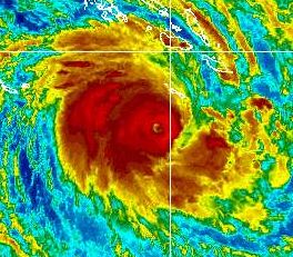
IMAGE: Ului weakened a little today but in the past couple of hours the eye has started to form again. Image / GOES, NOAA
The severe tropical cyclone is predicted to become an intense Category 5 cyclone overnight tonight NZT with winds gusting up to 350km/h later on Tuesday.
Computer models show the cyclone will brush the Queensland coast and WeatherWatch.co.nz says coastal damage could be severe with “phenomenal seas” likely.
Current estimated time of arrival for Ului in Australia is this weekend according to WeatherWatch.co.nz with northern New Zealand potentially in the firing line around Wednesday next week.
Mr Duncan says it’s still too early to know what sort of impact Ului will have on New Zealand, if any, and for now his focus remains on Cyclone Tomas and the immediate threat it poses to Fiji.
“So far one fatality has been reported but it’s certainly a concern that there could be more – this storm is fierce”.
Cyclone Tomas poses no threat to New Zealand.
Comments
Before you add a new comment, take note this story was published on 15 Mar 2010.


Add new comment
kiritopa on 15/03/2010 3:36am
SUVA, Fiji ‚Äì Cyclone Tomas battered island groups off Fiji’s northern coast Monday, causing flooding and pounding seas, but as residents braced, officials said the storm likely would only sideswipe the main islands of the South Pacific nation.
Some 6,000 residents fled to cyclone shelters ahead of the storm, which was already battering the Lau and Lomaiviti island groups, National Disaster Management Office director Pajiliai Dobui said.
Dobui said the cyclone’s latest track would carry it offshore from the main islands of Vanua Levu and Viti Levu, where most of the population lives, causing minimal impact on infrastructure such as buildings, electricity, water supplies and roads in those areas.
Reply
Guest on 15/03/2010 12:28pm
I am in a hotel room in downtown suva right now and I am waiting for the brunt of tomas which should hit from about 9am (wednesday).
At the moment the wind is blowing at around 10 to 30 knots and should increase to atleast 65 knots early in the morning.
There has been a curfew and the streets are empty.
I hope damage is minimal and I sincerely hope there are no fatalities.
Reply