Sub-tropics about to bring days of rain to some parts of New Zealand (+5 Maps)
9/02/2018 2:26am

> From the WeatherWatch archives
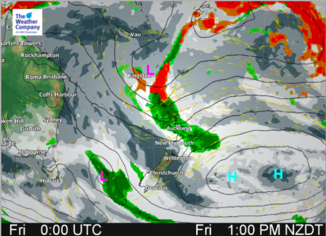
A low just north west of New Zealand is slowly moving southward, bringing locally heavy rain to the country this weekend.
Northern parts of the North Island will be under the influence of the low pressure system for a number of days and rain accumulation will continue and increase through this weekend.
There’s a fine line between the heaviest rain and just drizzly patches – click here to read more about that.
Even though the area with the heaviest rain isn’t overly large it is slow moving and so therefore risks of flooding and and slips increases, especially around the ranges.
By late Saturday and into Sunday locally heavy downpours may also fall over the upper South Island.
The peak chance for rain in the South Island will be from Saturday night to Monday morning, while in the North Island it may linger well into next week.
There may be some isolated thunderstorms with downpours too.
Not everyone will get the rain though – the lower South Island may miss out on a fair chunk of this sub-tropical rain maker.
Into next week the area of rain could become incredibly narrow – but may linger for a few days in the same area (potentially the central part of the North Island). It’s one to watch and due to the very narrow slow moving nature of this forecast rain the areas affected may shift around a bit. We’ll keep you posted.


Separate to the low coming in this week there are two other areas of low pressure around Fiji to keep an eye on:
– WeatherWatch.co.nz
Comments
Before you add a new comment, take note this story was published on 9 Feb 2018.


Add new comment