Sub-tropical low may brush Northland but skip other regions (+4 Maps)
15/11/2017 11:24pm

> From the WeatherWatch archives
The second large sub-tropical low in a week is moving towards New Zealand but it looks like a repeat performance with again the bulk of the wind and rain remaining out at sea. Despite the low naturally wanting to move directly down over the North Island, a blocking high over the country and the Tasman Sea will put the brakes on this low dropping too south – then it will help guide it away from New Zealand on Sunday.
The closest the centre of the low will get appears to be on Saturday PM where the chance for rain (and possible heavy falls) remains for Northland. This is different from last week, where Northland was mostly dry. Again, there is a chance this rain band my just hover offshore – but the data has been indicating for a number of days that Northand is most exposed to rain from this low – which may be welcome by many farmers and growers as the region starts to dry out in places.
Further south and – for now – Auckland and Bay of Plenty look dry with sunny spells. However showers and patchy light rain and drizzle may affect East Cape, Gisborne and potentially even Hawke’s Bay.
As of Thursday morning the forecast for this weekend showed most severe weather risks were out at sea – but those in northern New Zealand should keep up to date with all forecasts, weather videos and news stories to ensure nothing changes. These 50/50 set ups can often involve an incredibly fine line of distance between heavy rain and completely dry – as we experienced last weekend.
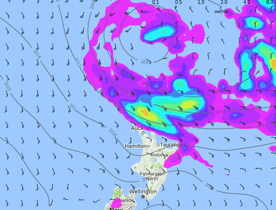
 4AM SATURDAY shows an intense low just offshore, but weakening slowly as it runs into high pressure around New Zealand. 98% of the rain is offshore.
 4PM SATURDAY the rain clouds are over parts of Northland and the East Cape/Gisborne area. This may be as close as the rain band gets to other regions but continue to monitor our maps for the latest. Rainfall totals don’t appear to be concerning at this stage.
 4AM SUNDAY shows most northern areas dry now.
 4PM SUNDAY and the high from the west is pushing in and the low to the east is falling apart. SE wind flow means a few showers in Hawke’s Bay/Gisborne area, otherwise dry.
– Maps by Weathermap.co.nz
– WeatherWatch.co.nz
Comments
Before you add a new comment, take note this story was published on 15 Nov 2017.


Add new comment