> From the WeatherWatch archives
The spring southerly will peak today over the country with the coldest air and heaviest showers – but the most intense winds were last night around Banks Peninsula and Christchurch. Today it’s a windy day over the North Island and upper South Island with gales at times, but gradually the worst of the winds will ease over Thursday.
The stormy weather is mainly being created by a “squash zone”. If you look at our map (below) you can see the intense high pressure system out to our west. In August it was a similar placed high that helped create the nationwide polar blast – today and last night it was the squash zone on the edge of this intense high, and a deepening low out to New Zealand’s east that produced the hurricane force winds – not just a “storm” or low by itself. If we didn’t have this big high, we wouldn’t have “stormy” conditions over the country.
 Big high to the west, fairly small but deepening low to the east / weathermap
The ‘squash zone’ refers to where all the isobars squash up on the map – in today’s case that is between the intense high to the west and the deepening low to the east and the two are creating strong winds, cold southerlies and the rest of our weather.
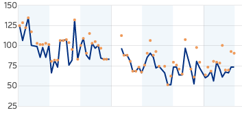
As of 7:30am winds around Christchurch, the Port Hills and Banks Peninsula (the areas most exposed to hurricane force winds overnight) were still gusting to 100km/h or close to it even in parts of the city, but peak winds are definitely down. With the Port Hills and Banks Peninsula recording wind gusts between 150 and 160km/h last night and into the early hours, but the graph below shows how the winds have started to drop back this morning, with gusts now only just making it to 100km/h. It’s cold too – with windchill as low as -7 around parts of Christchurch city as of 7:30am.

Meanwhile further south it was Otago and Dunedin hit by the strong southerly first. Again hurricane force winds hit the area, especially Otago Peninsula where gusts climbed up to around 140km/h. Dunedin had damaging gusts for a time before the southerly headed into Canterbury where it stalled for several hours.
Current windchill in Dunedin is around 2 degrees with air temps around 6 degrees as of 7:30am.
Further inland and some alpine areas have windchill of -13, like near Fairlie.
In Wellington and the southerly was pretty strong overnight but by Wellington standards it was relatively normal weather. Hutt Valley seems to have been hit the hardest with some of the gusts coming straight in from the South Pacific Ocean and directly into Hutt Valley. Winds are still gusting to 110km/h in some exposed part of the city and region, although downtown isn’t so fierce.
It’s cold too, with temperatures hovering around 2 to 5 degrees in Wellington and windchill currently down to -4 in the Capital.
Snow has closed SH2 on the Rimutaka Ranges and WeatherWatch.co.nz expects snow flurries across the ranges down to 300 or 400m today. Snow will also affect Waiouru, Ohakune and the Hawke’s Bay ranges.
Hail showers are affecting many western areas, including Auckland, Taranaki and Waikato.
Today the cold southerly sets in across the North Island’s east coast and gradually eases in the South Island.
In true spring style temperatures warm back up again this weekend. Keeping in mind current temperatures and windchill, by this Sunday Dunedin will have a high of 15 degrees and Christchurch 17 degrees.
Snow or Hail??
This photo was sent to us from Hutt Valley showing a very white looking silver car – it’s most likely an intense hail shower, or graupel, but we can’t rule out a few snow flurries to low levels this morning too in the North Island, especially along the southern and eastern ranges.
However we have had reports of light snow flurries here and there at higher altitudes around Wellington, so we can’t rule it out this morning!
hmmm, it’s mornings like this in the Hutt you wish the toilet seat was heated. @WeatherWatchNZ pic.twitter.com/IJnJtVkK8c
— MissBetseyTrotwood (@Suzyiam) September 7, 2016
Comments
Before you add a new comment, take note this story was published on 7 Sep 2016.


Add new comment
Owen on 8/09/2016 12:08am
We had sleet this morning around 7:15am little flakes of ice gently floating down onto our deck. Wasn’t hail hardly made a sound. Amazing we are off Mountain Road in the Waitakere Ranges are sit at about 300 meters or 984 feet
Reply
Dean Lawrie on 7/09/2016 8:30pm
As I was driving to work in Lower Hutt from Upper Hutt there was an intense hailstorm which would have been what coated this car and many others. The clouds of the ‘storm’ were thick enough to darken the sky to almost black as it approached snd while in the dounpour the only light I saw was from artifical sources. The hail didn’t so much land on the windscreen as it was more hitting the windscreen and bouncing off in smaller chunks. When I got to work several cars were coated by the hail like the one in the picture.
Reply
Allan on 7/09/2016 8:18pm
Currently snow flurries in Kingston, elevation 95 meters!
Reply