Southern Ocean storm to roar into NZ on Friday, kicks off windy wintry weekend (+8 Maps)
1/08/2019 4:48am

> From the WeatherWatch archives
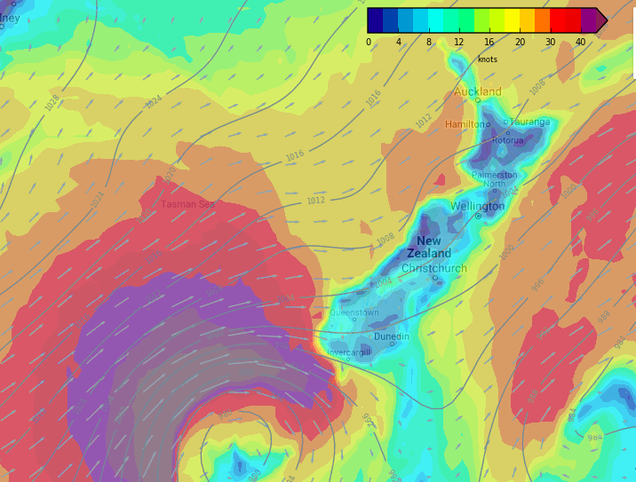
A storm in the Southern Ocean is rushing towards NZ and will hit the South Island on Friday before breaking up over the North Island on Friday night and Saturday. It’s the beginning of a wintry blast of weather coming in across New Zealand for four days, not easing until Monday night with the cold peaking on Sunday and Monday, after the main winds.
The storm is being enhanced by a giant high pressure system stuck over Southern Australia, creating a big ‘squash zone’ of air pressure on the western side of this incoming Southern Ocean low, an area with hurricane force winds (sustained over 120km/h). Here’s the better news, the worst of the winds (the hurricane force portion) will fall apart at sea and as this low slams into Fiordland National Park in the very remote south west corner of the country between midnight tonight and dawn Friday the big mountains will help weaken the system further.
The bad news is the Southern Alps will also ‘squeeze’ this winds through valleys and over the ranges and this will create pockets of severe gales. Please see Government forecaster MetService for tax funded public regional weather warnings.
To make matters more confusing the tightly packed air pressure around the centre of the low means as the low moves in on Friday the winds will change direction, turning much colder polar southerly by evening, then milder on Saturday. As the low pulls away on Sunday even colder air moves over NZ for Sunday and Monday.
WIND CHILL ALERT:
Farmers: Wind chills over the coming days will be extreme in Southland and Otago, possibly the West Coast and some exposed parts of Canterbury too – also the Central North Island. Double digit negative wind chills are possible (-10, 11, 12C etc) in exposed areas in peak cold. Winds this cold will be deadly for newborn animals. Windier weather makes for brutal wind chill, so there may be some lulls in the cold as winds ease or shift around. Peak cold looks to be on Sunday/Monday, but Friday evening/night also looks bitterly cold with gale force southerlies in some South Island regions.
SNOW ALERT:
Snow levels will drop to lower levels this weekend – but will be more confined to the western and south western corners of both islands. The bulk of the lower level snow will be in Fiordland, Southland and Otago. While there will be a polar southerly change on Friday, the lowest snow levels will be on Sunday and Monday. Heavy snow may fall to sea level in Milford Sound on Sunday and while snow totals will be much lower over the ranges parts of Southland and Otago may see snow to low levels, such as 100 or 200m. The further east you are, the lighter the amounts will be. Warmer than average soil temperatures will also see lower level snow melting fast and not settling.
SWELL / MARINE / BEACH ALERT:
Huge swells coming out of the Southern Ocean will pound the western coastline of both islands with waves over 8 metres. This is significant and very dangerous. Boaties and those fishing on the rocks are advised NOT to go out from Friday through the entire weekend in western areas and into Monday. Dangerous seas coupled with severe gales (50knots plus) will continue through until Monday and Tuesday in exposed marine areas, especially in the west and south.
SWELL MAP (Generally covers Friday PM, Saturday)
GALE ALERT:
FRIDAY: The peak area of gales moves into the South Island with strong coastal southerlies (gale force) in exposed areas on both western and eastern coastlines later in the day or night. The North Island steadily sees westerly winds rising over Friday, then easing over Saturday as the south to south west change moves through.
SATURDAY: Windy over the eastern North Island, easing elsewhere gradually. Still a little windy through western central parts of NZ on Saturday evening though.
SUNDAY: Colder SW winds move in, not too strong for some places but certainly cold. Western coastal areas look to be windiest, and the ranges. Winds increase at night in many places and into Monday and the air gets colder as well – peak wind chill weather (feels colder than it is).
MONDAY: Cold windy SWers across the country, finally ease by evening. (Warmer sub-tropical breezes possible for some next Tuesday in the north too).
PEAK WINDS: Look to be Friday, Friday night and Saturday AM. But windy weather continues in a number of regions through until Monday night.
WIND MAPS:
Midnight Tonight – The storm in the Southern Ocean reaches the remote Fiordland National Park:
6AM FRIDAY – Windier weather moves across the South Island: 
NOON FRIDAY – Gales spillover into eastern areas of the South Island in some areas, gustier winds move into the North Island:
6PM FRIDAY – Wintry southerly change moves up the South Island, gales in coastal areas on both western and eastern exposed areas. Gales through Cook Strait and central regions:
MIDNIGHT FRIDAY – Gales move up coastal South Island, gales in exposed parts of the North Island and blustery conditions further north (mainly below gale):
6AM SATURDAY – Winds easing over the South Island slowly:
NOON SATURDAY – Winds easing back further in many areas, but still a little blustery in coastal and exposed areas:
– WeatherWatch.co.nz
Comments
Before you add a new comment, take note this story was published on 1 Aug 2019.


Add new comment