Some rain for parched north next 48 hours + is that another cyclone on the horizon? (+7 Maps)
23/01/2022 8:32pm

> From the WeatherWatch archives
Due to Wellington Anniversary we have no video update today — Northern NZ has had four years below normal rainfall and this summer is proving to be another dry one for many.
It’s more evidence that when La Nina is weak to moderate and short lived, NZ is on the outer edges of it. Of course February and March are when the sea surface temperatures in the tropics reach their peak and so we’re not finished yet with rainfall chances from the north. An ex-tropical cyclone can dump one to two months worth of rain in just 24 hours, which is why so many were keen for Cody to make more of a direct hit.
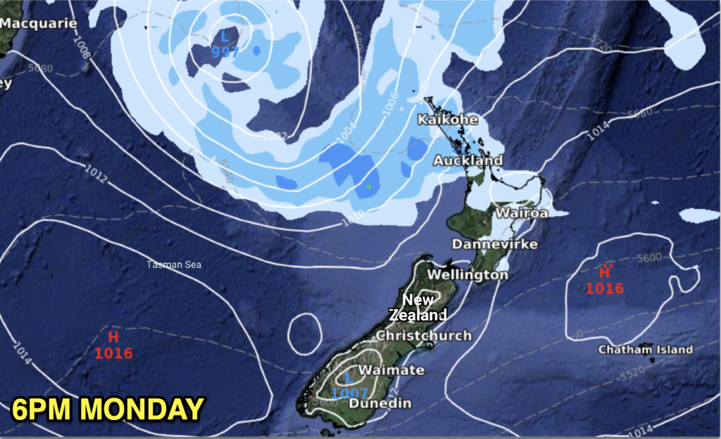
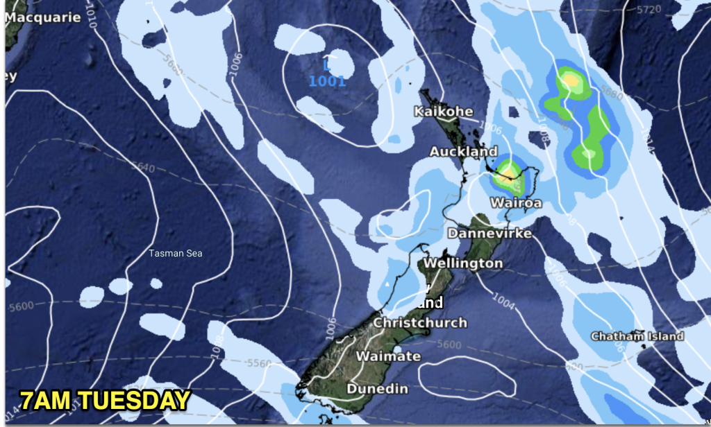
This week kicks off with a fairly weak rainmaker to the north of NZ and it’s bringing in some wet weather – but the totals aren’t huge. We’re seeing values of 10 to 35mm for the most part. This will be helpful and very welcome – but it falls well short of what northern NZ needs.
In fact, the very top of the North Island – the Far North – has seen native trees suffer in the nearly half-decade-long rainfall deficit. Auckland City has had water restrictions off and on for years now as the city once again endures below average rainfall.
While the weather pattern has shifted this year, the high pressure zones in summer can dwarf our small nation and that’s we’ve been experiencing so far this year.
Helpful rain today and tomorrow in the top half of the North Island, but for many it will still be frustratingly short of what is needed. We’re keeping an eye on the tropics – the next low to head southwards with the next chance of rain looks to be around Jan 31 to Feb 2.
LONG TERM RAINMAKERS
Another tropical cyclone is expected to form north of NZ in the coming week, most likely in the Fiji / Vanuatu area. There is currently no threat to land in the tropics at this early development stage.
Long term and both GFS (American) and ECMWF (European) modelling show the tropical storm (or depression) entering the Tasman Sea late January/Feb 1. Unlike Cody, which came in from the north to north east, this system is looking more likely to come in from our north to north west. If this is the case this bodes better for rainfall than Cody (with tropical lows the bulk of the rain when they reach NZ is often in the south eastern corner of that low, so when Cody’s centre was east of NZ the rain was even further east). If we can get a low in the Tasman, to our west, this often bodes better for rainfall chances in the North Island…but potentially for severe weather into the South Island too.
It’s too early to lock in. For now we’re monitoring the globe’s most accurate long term computer modelling and we have no sudden forecast of rain for northern NZ beyond the patchy rain today and tomorrow. However once the long range modelling and data becomes more locked in (end of this week) we can start getting more specific as to who has the chance of rain, and who might once again miss out.
THE MAPS
TODAY (MONDAY) AND TOMORROW (TUESDAY).


LONG RANGE:


WeatherWatch.co.nz / RuralWeather.co.nz
Comments
Before you add a new comment, take note this story was published on 23 Jan 2022.


Add new comment