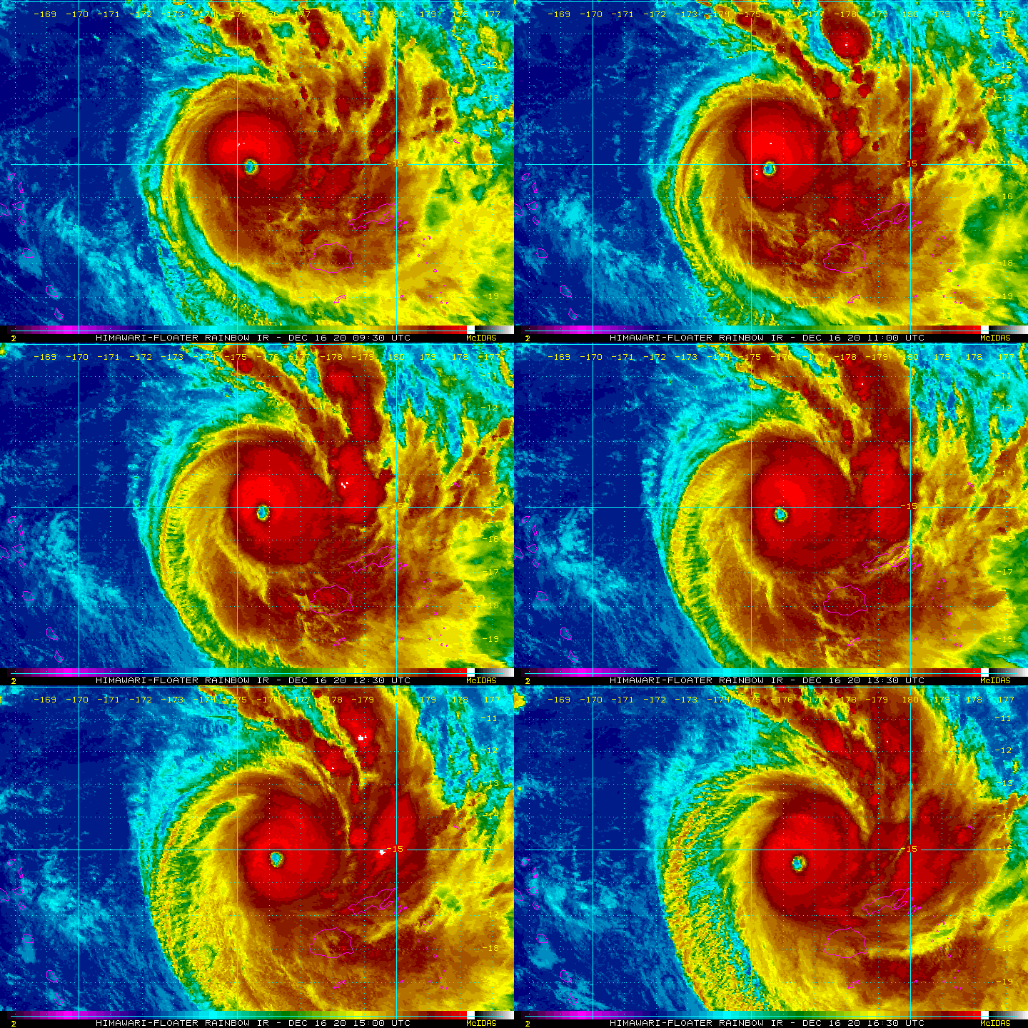
Severe Category 5 Cyclone YASA makes landfall in Vanua Levu, Fiji – now exiting (+21 Maps)
17/12/2020 11:13am

> From the WeatherWatch archives
Updated Friday 0:11am NZDT — Powerful and historical Cyclone Yasa has made landfall in Vanua Levu, Fiji and the centre has now exited.
Destructive, life threatening, weather may continue across the Fiji islands for the next 24 hours, but the eye of Yasa has now moved south east out of Vanua Levu.
While still a major Category 5 cyclone WeatherWatch.co.nz says there are some small signs of weakening with the eyewall partially collapsing, plus the storm is moving swiftly across Vanua Levu with it clearing early overnight. This is a positive. While this major cyclone is destructive and deadly the less amount of time it spends over land the better. It will be moving out away from the two main islands over the next several hours.
However the cyclone will now be moving into the smaller islands further south, south east and east of Suva.
YASA remains a Category 5 Severe Tropical Cyclone and brings life threatening and destructive weather conditions. Follow the advice of local authorities anywhere in the Fiji island group – the entire nation is exposed to severe weather from Cyclone Yasa – in some areas to the south until Saturday morning.
EARLIER:


Air pressure peaked this morning at 899hPa (hectopascals). It has now lifted a little to 907hPa. This is *incredibly* low air pressure and the 899 reading places Yasa in the history books for the Australia/Pacific region.
Yasa is the fourth most powerful ever Tropical Cyclone recorded in the South Pacific region. Records date back to 1982 in the South Pacific region.
The lower the air pressure the stronger the winds get and the higher the storm surge is, generally speaking. The slight change from 899hPa to 907hPa will make very little difference overall but is perhaps a sign the storm has peaked in intensity with the Fiji islands now disrupting the flow.
This remains a major event for Fiji.
Sea surface temperatures are 28/29 degrees Celsius in the area with La Nina fuelling this storm.
Average winds have reduced a little from 260km/h this morning to 240km/h now. Still, this remains a powerful Category 5 cyclone.
Rain radar from the Fiji MetService did show the cyclone clearly moving in but, as expected, radar has now gone down (assuming from power outages) on Vanua Levu.


EARLIER STORY: 10am:
Intimidating – that is one word to sum up this incredibly early season Category 5 South Pacific Cyclone which is directly aiming for Fiji today and overnight tonight.
Severe Cyclone Yasa is a very powerful cyclone, one of the most powerful on record in the South Pacific and certainly one for the history books – and this is before it’s even reached Fiji properly.
As of 10am NZDT Thursday here were Yasa’s stats:
- Central Air Pressure: 899hPa
- Sustained Winds: 250km/h
- Gusts: 305km/h
- Maximum Wave Height: 12 metres
- Storm direction: Tracking 105 degrees at 11 knots/20kmh (at 7am it was heading 110 degrees at 06 knots/11kmh). Put another way, it’s speeding up and starting to turn more southwards, as forecast.
EXACT TRACKING TONIGHT IN FIJI:
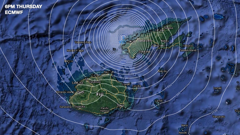
Until the cyclone actually moves in the very precise position of landfall is tricky, but the varying models we trust at WeatherWatch.co.nz and IBM show this storm is on track to likely make landfall on Vanua Levu this evening.
There is also some chance the cyclone could track over the Bligh Waters between Vanua Levu and Viti Levu and not make a technical landfall on either main island.
Either way, this storm is expected to pack a punch. This more eastern track (as earlier this week it looked as though Yasa may be just west of Fiji) exposes many low lying islands south east of Fiji’s main islands to being completely inundated by Yasa’s storm surge.
TIMING:
- Severe weather starts today Thursday and ramps up this afternoon and evening
- Landfall could be as early as late afternoon and as late as tonight or overnight tonight.
- Cyclone Yasa will likely start to clear Fiji’s two main islands on Friday morning
- Cyclone Yasa will likely clear Fiji island group on Saturday to the south
- Keep up to date with the Fiji Met Service for official tracking and timing.
YASA’S POWER:
This storm has the ability to swamp entire islands, inundate entire coastal communities, wipe some small islands off the map entirely, destroy buildings, bring down trees and cause slips and flooding. The most destructive part of this cyclone will be 150km either side of the centre.
Heavy rain will affect the entire region – and has done so for the past day. 250 – 300mm of rain is possible over the next 2 days.
Huge waves, up to 12 metres, will pound the normally calm northern coastline of both main islands with dangerous seas wrapping around other coastlines.
With Yasa now expected to track further south east this will seriously impact dozens of small islands east of Suva.
GOOD NEWS?
If Yasa does continue to track further east as modelling and Fiji MetService tracking suggests, this could spare western Fiji (Nadi) from the very worst. In saying that, everyone right across Fiji shouldn’t be letting their guard down with a cyclone this enormous and powerful incase it shifts a little from computer modelling.
Yasa is also expected to track faster away from the main islands than originally expected. It may be clearing the two main islands as early as before dawn Friday. However GFS modelling (US) shows it lingering longer over the Bligh Waters and not clearing to the south until Friday daytime.


Comments
Before you add a new comment, take note this story was published on 17 Dec 2020.


Add new comment
Priscilla on 17/12/2020 4:54pm
Very informative and gives us hope this storm will pass. Prayers to the whole of Fiji and to our ❤️ Ones out there.
Reply
Ash Patel on 17/12/2020 10:16am
Fiji, you are in my prayers, God protect you.
Reply
Salote Rabuka on 17/12/2020 8:38am
Excellent! VINAKA NZ.
Reply
Artikris on 17/12/2020 5:45am
God bless my FIJI nd other islands
Reply
Briggs Le Roux on 17/12/2020 4:30am
God bless you Fiji may you all be safe.
Reply
Mila on 17/12/2020 2:11am
Fiji, you are in my Prayers!!!
Reply
Ann on 16/12/2020 7:28pm
My heart goes out to the people of Fiji. After feeling the direct impact of Cyclone Harold earlier this year I know how terrifying a monster storm like this can be. Kia Kaha Fiji.
Reply
Tofatu Vaeluaga on 18/12/2020 11:15pm
Hows the cyclone in fiji now
Reply
View more comments