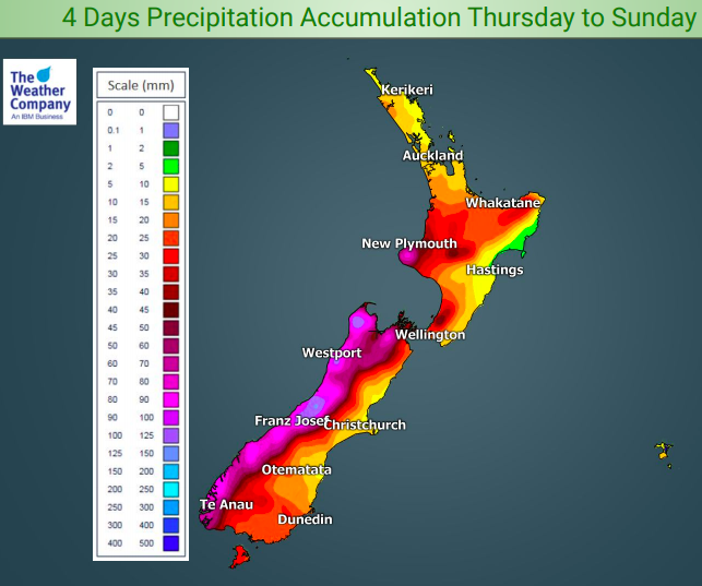
Rain on the way for all of NZ due to Mother’s Day low – here’s how much is forecast:
9/05/2019 12:52am

> From the WeatherWatch archives
We have a weak area of rain and showers moving up the western side of New Zealand today and tomorrow but a burst of heavier more nationwide rain moves across the country on Mother’s Day.
The Mother’s Day low will move in from the Tasman Sea on Sunday and is likely to bring heavy rain to the West Coast and a burst of rain across all of the country with varying amounts – the bulk in the west, lower amounts in the east.
As the low crosses NZ over Sunday the wind flow will swing from warmer than average northerlies to colder southerlies – this will bring snow to the mountains and ranges, especially the South Island. This transition will see some wet weather move in to eastern areas before high pressure returns by Monday afternoon.
The wettest areas (ranges of the West Coast) will receive up to 150mm while eastern areas, like Gisborne, may only get 5mm.
As for Mother’s Day itself, keep up to date with your local 10 day forecasts at WeatherWatch.co.nz, which includes hourly chance of rain to help better plan your day. Also, our weather videos out today and tomorrow with Philip Duncan will focus on Mother’s Day weather across NZ.

– WeatherWatch.co.nz
Comments
Before you add a new comment, take note this story was published on 9 May 2019.


Add new comment