> From the WeatherWatch archives
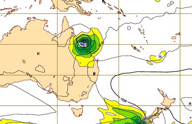
It’s very early days but for almost a week now weather models have been predicting one thing for Queensland – a direct hit by a tropical cyclone at the end of next week.
WeatherWatch.co.nz has been monitoring a predicted tropical storm in the long range weather models since the end of last week but has only today decided to publish these predictions.
On top of the recent loss of life and catastrophic flooding we felt there was no need for early discussion on this potential storm, however after almost a week of fairly consistent weather models we believe we can predict, with some confidence, that a severe tropical cyclone will track from Vanuatu / New Caledonia to the Coral Sea and into the Queensland Coast sometime next week.
Follow us on FACEBOOK
The tropical depression is expected to form north east of Fiji in the coming 24 to 48 hours with the system passing north of the main island and towards Vanuatu and New Caledonia. It’s too early to know if the system will be severe at that time.
Tracking shows it travelling westwards and making landfall most likely between Townsville and Cairnes, although landfall could be anywhere along the Queensland coast.
WeatherWatch.co.nz will keep you up to date on this developing low in the coming days.

Above – GFS map shows a deep low between Vanuatu and New Caledonia on Monday January 31st
Below – ECMWF shows that same deep low making landfall between Townsville and Cairns on Thursday or Friday next week
Comments
Before you add a new comment, take note this story was published on 26 Jan 2011.


Add new comment