> From the WeatherWatch archives
A southerly change will move up and over the country starting later this weekend in the South Island then crossing the entire country by Monday and Tuesday, fading to some degree as it heads to the very north of the country.
In true Autumn style it’s fairly short lived but it’s also one of the bigger cold snaps of the year so far with a big reduction in daytime highs coming, even for areas that have been summer-like lately.
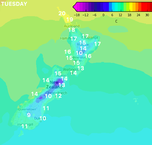
Single digit highs are possible next Tuesday through the South Island interior with highs failing to reach the teens in a number of main centres and regions across the island. The North Island also feels the cool down with eastern areas tumbling as much as 13 degrees on where they were mid this week.
The colder air will even reach Northland with highs still making it to 19 or 20 degrees, but that’s at least 5 degrees cooler than it has been.
Next week looks likely to remain cold for lower half of the South Island but will start to slowly warm up later in the week to more average April levels, but WeatherWatch.co.nz says this week will be much warmer than next week will be pretty much everywhere across New Zealand.
COMPARE THE COLDER AIR – FROM NOON THIS FRIDAY (TOP) TO NOON NEXT TUESDAY (BOTTOM):

– Maps by Weathermap.co.nz, temperatures added to Tuesday’s map by WeatherWatch.co.nz
– WeatherWatch.co.nz
Comments
Before you add a new comment, take note this story was published on 5 Apr 2018.


Add new comment