> From the WeatherWatch archives
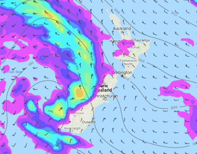
A slight pause in the weather on Monday especially out east due to a ridge of high pressure however more inclement weather is lined up for the South Island from evening then the western North Island overnight as a front pushes in from the Tasman Sea.
For the upper North Island expect sunny spells, perhaps a morning shower or two mainly out west. High cloud increases from afternoon with northwesterly winds tending northerly in the evening then freshening. The lower western North Island has a mostly cloudy morning with showers then easing, drying out for a time from afternoon for areas south of Taranaki with some sun breaking through then overnight rain moves in for all with heavy falls. Northerlies strengthen later in the day.
Mostly sunny for the east coast of the North Island with some high cloud, starting to thicken up from afternoon. Northwesterlies tend northerly in the evening and start to increase.
A cloudy day for the South Islands West Coast, showers then rain moves in late afternoon with heavy falls, northeasterly winds strengthen during the day then changing north to northwest in the evening. Nelson has some sun and thickening cloud, showers then rain moves in during the afternoon becoming heavy in the evening before easing overnight. Marlborough is mostly sunny with increasing high cloud, rain moves in during the evening then becoming heavy later.
Canterbury is mostly sunny with increasing high cloud, rain becomes heavy about the high country late afternoon or evening. Northerlies tend northeast in the afternoon then freshen, staying mainly dry nearer the coast. Sunny areas and developing high cloud for Otago, northerlies tend northeast in the afternoon. Cloud thickens and lowers in the evening. Southland is similar to Otago however there could be a few morning showers which clear then in the evening a few further showers may move back in mainly out west.
The warmest temperatures tomorrow will be about the North Islands East Coast and for Northland / Auckland, getting into the mid to high teens. The coolest temperatures will be for Southland / Otago and along the South Islands West Coast with temperatures in the high single to low double figure arena.

Image: Monday 15th July 3:00pm MSLP / rain map – weathermap.co.nz
WeatherWatch.co.nz
Comments
Before you add a new comment, take note this story was published on 14 Jul 2019.


Add new comment