Models suggest a tropical low may form north of NZ next week (+Maps)
9/02/2017 5:30pm

> From the WeatherWatch archives
It’s early days but a trend in the models is developing this week – they are picking a tropical storm to form north of New Zealand within the week and it may drift our way.
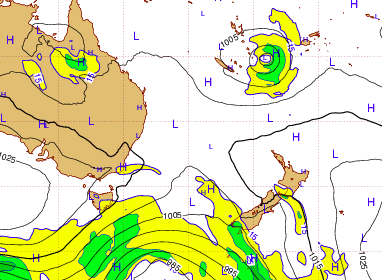
Latest guidance from the best computer models out of both Europe and the US suggest a large area of low pressure developing and deepening next week between Vanuatu, Fiji and New Caledonia.
Around one week from now these forecast models show the low drifiting south towards New Zealand with a very large high to the east of the nation which could help guide the low towards us.
For those who remember Cyclone Winston last year you’ll also know not every low comes straight to us from the north – they can turn east or west and not affect us. So we’ll be keeping a close eye on the models, but our own forecasts suggest this low may be in a ‘good’ position to approach northern New Zealand next weekend.
“With a neutral weather pattern affecting New Zealand the weather can come from us at all four angles” says head weather forecaster Philip Duncan. “This week we saw highs in the mid 30s in the east then an usual wet south east change which brought heavy rain to dry areas. Next week our weather comes in from the west but forecaster eyes will be looking north now too to see if this low will come our way”.
Lately there are a number of tropical lows and storms from Australia to Fiji, mostly bringing flooding rains and not so much wind.
WeatherWatch.co.nz will keep you posted – and remember to check our maps page along with the 10 day % of rain in our forecasts to help get a better understanding of if you might be impacted or not. We expect to be able to better lock things in by Monday. “When a low comes in from the north it’s always a bit like balancing an egg on a roof. It will often roll down one side or the other, but every now and then they can sit in the middle – those are the lows that are more likely to bring heavy rain and strong winds to northern New Zealand and the modelling currently hints at this but it’s important to remember it’s still over a week away” says Mr Duncan.
WeatherWatch.co.nz says MPI and local councils will be closely monitoring this for potential rain chances in our driest regions.
 ECMWF for 7 days from now shows a low forming north of NZ and a blocking high to our east.
 Next Friday/Saturday around New Zealand – current forecast model by GFS/Weathermap
– WeatherWatch.co.nz
Comments
Before you add a new comment, take note this story was published on 9 Feb 2017.


Add new comment
Guest on 10/02/2017 9:39pm
I see the latest ECMWF model this morning doesn’t show the potential storm any more. Just shows how fickle they can be and the danger of making bold forecasts so far ahead.
Reply
Guest on 10/02/2017 7:25pm
In some ways this sounds like good news for the glum, grey rainy West Coast. Locals say down here that when the tropical lows start forming they keep the high pressure zones down lower where we are, so we begin to experience better, more settled weather. The downside of course is when those lows come down too low and smack us round.
Reply
Dave on 9/02/2017 11:53pm
Hi Phil
The tropics have really fired up over the last week or so I notice & it would be no surprise for us to be in the firing line for a couple of lows or cyclones.
That does look potentially quite nasty really so it will be interesting to see what happens. I certainly trust the models you are using as they are right most of the time, even at long range so it looks like it will happen.
I would be interested in your thoughts of another one following it not long afterwards as the ingredients look to be there for that to happen
Cheers Dave
Reply