Long Range: Tropical cyclone potential next week near New Caledonia ‘one to monitor’ for NZ.
29/03/2020 9:59pm

> From the WeatherWatch archives
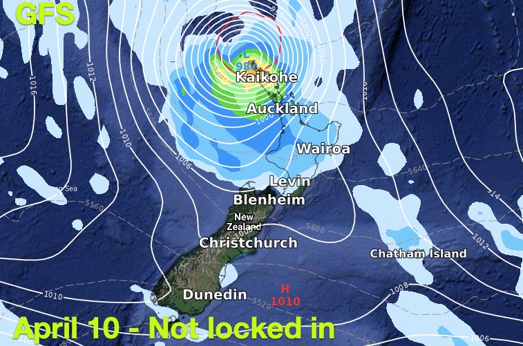
There is the chance of a Coral Sea tropical cyclone in early to mid April says WeatherWatch.co.nz after computer models again today agree the conditions are there next week for one to form.
While it’s too far out to know if New Zealand could be directly impacted the forecast storm would not only provide a welcome distraction from virus news but it also gives those in drought zones another reason to stay optimistic with some modelling suggesting the north of NZ might get some rain. Might – it is still too early to lock in.
This possible storm to our north west later next week may link with a more “normal” low pressure system in the Tasman Sea, giving a chance for wet weather to move into drought zones 10 days from now. Equally, high pressure may remain stuck over northern NZ guiding the low straight down through the Tasman Sea and into the Southern Ocean area (like Cyclone Uesi), or keep it well to our north as we saw recently with other subtropical lows. We won’t know for maybe even another several days if New Zealand will be impacted or not.
With the cyclone now showing up in publicly available long range maps we wanted to cover it – and we’ll keep a close eye on it with further detailed updates this Wednesday and Friday.
WHAT THE MODELS SAY FOR APRIL 8


WHAT GFS SAYS (not locked in this far out) for FRIDAY APRIL 10

WeatherWatch.co.nz – Exclusive
Comments
Before you add a new comment, take note this story was published on 29 Mar 2020.


Add new comment
Terrin on 31/03/2020 12:44am
Hello Phillip and the team at weatherwatch, are there any cold snaps/polar blasts in the forecast.
Reply
WW Forecast Team on 31/03/2020 1:07am
Hi Terrin
Not by the looks of things, perhaps a bit of tropical action down the line rather than something coming up from the south. Feel free to check out our maps here: https://www.weatherwatch.co.nz/maps-radars/rain/rain-forecast
You can use them to see where the weather systems coming up are moving in from.
Cheers
Aaron
Reply