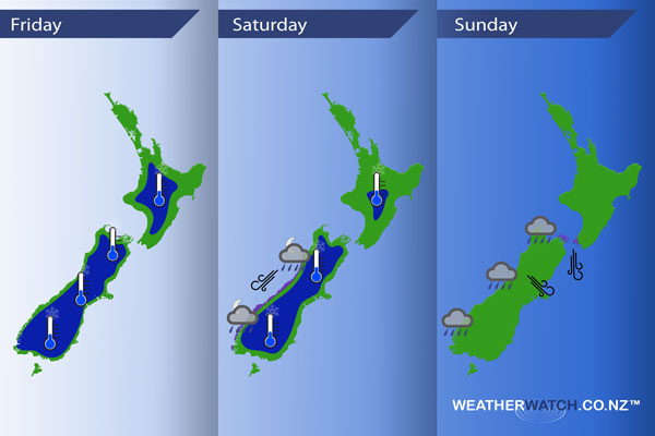
InfoGraphic: The Main Weather News Highlights across NZ: Fri, Sat, Sun
3/08/2017 7:00pm

> From the WeatherWatch archives
A ridge brings mainly settled weather for New Zealand today, for most this will mean mainly sunny conditions also however the east coast of the North Island still sees a few showers in a cool south to southeasterly airflow. A northeasterly airflow increases on Saturday ahead of a front which moves onto the West Coast of the South Island later in the evening / overnight. A north to northwesterly airflow lies over the country on Sunday.
Friday
Blue – A frosty start about inland parts of both Islands, heaviest about the inner / lower South Island.
Saturday
Blue – Another frosty start in the morning although not as bad as Friday morning.
Overnight rain moves onto the West Coast of the South Island which may be heavy in areas.
Purple – A north to northeasterly airflow increases over the South Island during the day, winds becoming gusty / strong about coastal fringes of South Westland from afternoon.
Sunday
Areas of rain for the West Coast of the South Island and about Nelson / western Marlborough during the day. While this rain may be heavy in areas it’s not looking overly persistent during the whole day. Northerlies through Cook Strait are looking brisk to strong while about inland Canterbury northwesterly winds may get a little blustery at times during the afternoon.

– Please note, the idea behind this update is to focus on the main weather highlights, which is why not all regions are mentioned.
For specific 10 day information for your city, town, rural community or island please see the 1500 forecasts on our homepage!
– Aaron Wilkinson, WeatherWatch.co.nz
Comments
Before you add a new comment, take note this story was published on 3 Aug 2017.


Add new comment