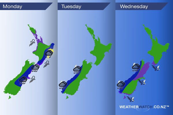
InfoGraphic: The main Weather News Highlights across NZ for next 3 days
11/12/2016 11:39pm

> From the WeatherWatch archives
A southwesterly airflow lies over New Zealand today, unstable for some regions. Settling down on Tuesday with southwesterlies easing, a northwesterly airflow builds over the South Island from evening however. West to northwest winds build further on Wednesday becoming strong overnight.
Monday
Blue – Rain this morning about Canterbury may be heavy with a chance of hail, even the risk of a thunderstorm too although that is a low risk. Conditions easing into the afternoon.
Marlborough has a risk of heavy showers and hail from afternoon, low risk of a storm here also then the east coast of the North Island has heavy showers, hail and a chance of thunderstorms from early afternoon.
Purple – Southwesterly winds brisk to strong about some coastal parts of New Zealand today.
Tuesday
Blue – Rain moves onto South Westland in the evening then further north overnight, heavy falls possible, mainly about South Westland.
Wednesday
Blue – Rain moves into South Westland again from evening then pushes northwards overnight, a greater chance of heavy rain this time for all.
Purple – From later in the evening and through overnight expect brisk to strong northwesterly winds to develop in the areas marked below. Winds may gust to gale for inland Canterbury / Marlborough, Cook Strait and about coastal Southland.

– Please note, the idea behind this update is to focus on the main weather highlights, which is why not all regions are mentioned.
For specific 10 day information for your city, town, rural community or island please see the 1500 forecasts on our homepage!
– Aaron Wilkinson, WeatherWatch.co.nz
Comments
Before you add a new comment, take note this story was published on 11 Dec 2016.


Add new comment