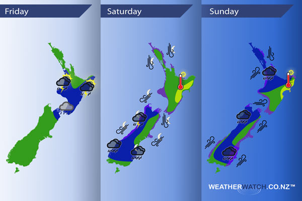
InfoGraphic: The main Weather News Highlights across NZ for next 3 days
19/01/2017 6:00pm

> From the WeatherWatch archives
Southwesterlies lie over New Zealand today with a ridge pushing in later on. Saturday sees our brief lasting ridge slip away to the east then a large and deep low moves towards the western side of New Zealand later in the day / overnight. This low crosses over the South Island on Sunday moving from west to east, a southwesterly airflow spreads over the country once the low passes out to the east.
Friday
Blue – Showers about the western North Island may be heavy with thunderstorms and hail this morning then easing away. About the east coast (especially the ranges) heavy showers with possible thunderstorms and hail may develop this afternoon then clearing away in the evening.
Early heavy showers about Marlborough / Nelson ease.
Saturday
Blue – Heavy rain moves into the West Coast of the South Island from evening, thunderstorms possible overnight especially for North Westland.
Purple – Strong to gale north to northeasterly winds develop about coastal parts of the upper South Island later in the evening / overnight. A similar situation for the western North Island.
Yellow – Temperatures reaching into the mid 20’s for a time in the afternoon about the eastern North Island.
Sunday
Blue – A front crossing over the upper North Island in the morning may bring some heavy rain then easing.
Areas of heavy rain across the South Island ease in the evening. While most parts of the South Island see rain the regions marked below show the heaviest areas at this stage.
Purple – Northerlies about the upper North Island in the east ease by midday. Strong southwesterlies spread over the South Island around midday with gales about coastal areas. Strong west to northwesterly winds push into the lower North Island in the west and through Cook Strait, easing late afternoon / evening. Brisk to strong southwesterlies expected about the upper North Island in the west from afternoon.
Yellow – Temperatures may get into the mid 20’s about Hawkes Bay / Gisborne for a time in the afternoon.

– Please note, the idea behind this update is to focus on the main weather highlights, which is why not all regions are mentioned.
For specific 10 day information for your city, town, rural community or island please see the 1500 forecasts on our homepage!
– Aaron Wilkinson, WeatherWatch.co.nz
Comments
Before you add a new comment, take note this story was published on 19 Jan 2017.


Add new comment