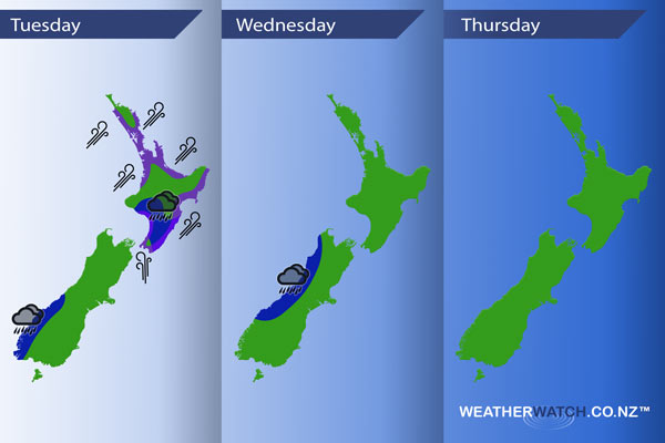
InfoGraphic: The main Weather Highlights across NZ for next 3 days
7/11/2016 7:31pm

> From the WeatherWatch archives
A strong southwesterly airflow eases later today for the North Island, northwesterlies develop about the lower South Island. A front slowly pushes northwards over the South Island during Wednesday while a westerly airflow lies over the North Island. Wednesday sees a front push over the South Island from the Tasman Sea while westerlies continue in the north.
Tuesday
Blue – There may be some early morning heavy rain about the lower North Island then easing. Areas of rain move into Fiordland from afternoon, perhaps not heavy till evening or overnight.
Purple – Brisk to strong southwesterly winds for parts of the North Island ease later in the day.
Wednesday
Blue – Some heavy rain for the West Coast of the South Island then easing during the afternoon.
Thursday
At this stage a front moves onto the South Island from the Tasman Sea on Thursday, this could bring some heavy rain to the West Coast of the South Island and perhaps the east coast (mainly Canterbury) however it doesn’t last very long so at this stage is not marked below although this could change.

– Please note, the idea behind this update is to focus on the main weather highlights, which is why not all regions are mentioned.
For specific 10 day information for your city, town, rural community or island please see the 1500 forecasts on our homepage!
– Aaron Wilkinson, WeatherWatch.co.nz
Comments
Before you add a new comment, take note this story was published on 7 Nov 2016.


Add new comment