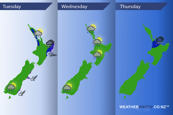
InfoGraphic: The main Weather Highlights across NZ for next 3 days
26/09/2016 6:00pm

> From the WeatherWatch archives
An east to northeasterly airflow lies over most of the country from today through till Thursday.
Tuesday
Blue – Rain about Gisborne and Hawkes Bay, possibly heavy at times. About Northland down through to the Waikato showers develop in the afternoon, some may be heavy with the low risk of a thunderstorm then easing in the evening.
Isolated showers may also develop about Southland / inland Otago late afternoon / evening, low risk of a heavy shower here.
Purple – Easterlies about coastal Gisborne will be fairly gusty, a similar story about coastal Canterbury / Otago with winds from the northeast.
Wednesday
Wednesday sees showers for much of the North Island during the day, a few of these may turn heavy late afternoon / evening then easing later in the day. It is quite hard to pinpoint any particular area this may occur however, mostly this will be on the western side of the island.
Isolated showers possible once again about inland Southland / Otago, one or two may be heavy late afternoon / evening.
Thursday
Blue – A band of rain about the Waikato and western Bay Of Plenty may bring a few heavy falls which eases by evening.

– Please note, the idea behind this update is to focus on the main weather highlights, which is why not all regions are mentioned.
For specific 10 day information for your city, town, rural community or island please see the 1000’s of forecasts on our homepage!
– Aaron Wilkinson, WeatherWatch.co.nz
Comments
Before you add a new comment, take note this story was published on 26 Sep 2016.


Add new comment