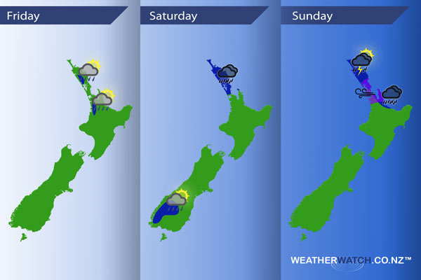
InfoGraphic: The main Weather Highlights across NZ for next 3 days
22/09/2016 7:00pm

> From the WeatherWatch archives
Weak anticyclonic conditions for much of the country today with light southerlies for most tending northeast about the upper North Island. A low moves towards the upper North Island on Saturday moving out of the Tasman Sea with northeast winds, light east to southeast winds cover the rest of the country. Easterlies cover most of New Zealand on Sunday with a low situated over Northland.
Friday
Blue – Low risk of an isolated heavy shower for some western parts of the upper North Island late this afternoon / evening.
Saturday
Blue – From afternoon rain moves into Northland reaching Auckland in the evening, chance of a heavy fall or two here.
Late afternoon / evening isolated showers are possible about Central Otago and the Fiordland ranges, a low risk one or two may be heavy.
Sunday
Blue – Areas of rain for parts of the upper North Island may be heavy at times. Northland during the afternoon could even see thunderstorms and heavy downpours due to large amounts of surface moisture present and warm temperatures.
Purple – Gusty easterly winds are likely about the Auckland region, winds may be strong at times.

– Please note, the idea behind this update is to focus on the main weather highlights, which is why not all regions are mentioned.
For specific 10 day information for your city, town, rural community or island please see the 1000’s of forecasts on our homepage!
– Aaron Wilkinson, WeatherWatch.co.nz
Comments
Before you add a new comment, take note this story was published on 22 Sep 2016.


Add new comment