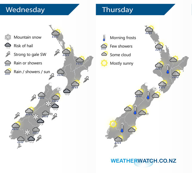
InfoGraphic: The Big Picture for Wednesday / Thursday
1/10/2019 6:00pm

> From the WeatherWatch archives
Strong southwesterlies lies over the country today, a cold front within this flow races northwards over New Zealand during the day. Southwesterlies ease on Thursday.
A mainly dry morning for the upper North Island then showers move in during the afternoon as southwesterlies strengthen, winds may rise to gale about western coastal areas then easing overnight. A dry morning for the lower and eastern North Island (although a few early showers clear Gisborne), rain moves into Wellington and Wairarapa early afternoon then Hawkes Bay and Gisborne mid to late afternoon as a strong south to southwest change pushes through. Morning rain eases to showers, clearing in the afternoon for the West Coast. A period of rain or showers develops around midday for Nelson / Marlborough then clearing in the evening, some snow possible to 500m for a time. Morning rain for Canterbury then easing to showers, clearing by evening south of Banks Peninsula then further north overnight. Snow may lower to 400m about Canterbury before clearing away. Early rain eases to showers about Southland / Otago then long dry spells developing in the evening, snow flurries to 300m.
Cloudy areas and the odd shower for the western North Island on Thursday, the Bay Of Plenty has a mainly sunny morning then cloud increases. Dry with some sun about Hawkes Bay and Gisborne, a shower or two may move in by late afternoon. Mostly sunny about South Westland, cloud increases further north with a shower or two likely north of about Greymouth during the day. Cloudy areas for Nelson and Marlborough, perhaps a shower or two also. Canterbury sees any morning cloud break to sunny areas, the odd shower on Banks Peninsula clears in the evening. Cloudy areas about Southland with a shower or two, morning cloud then afternoon sunny spells for Otago.

By Weather Analyst Aaron Wilkinson – WeatherWatch.co.nz
Comments
Before you add a new comment, take note this story was published on 1 Oct 2019.


Add new comment