> From the WeatherWatch archives
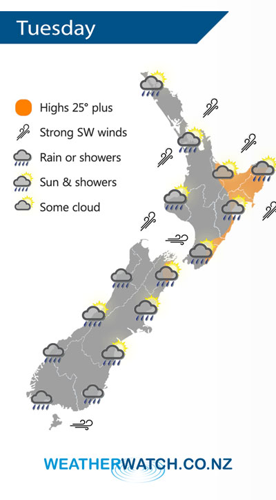
Ex Tropical Cyclone Hola departs moving southeastwards on Tuesday away from the east of the North Island meanwhile a southwesterly airflow spreads over New Zealand.
A southwesterly airflow lies over New Zealand on Tuesday, while gales are not looking as likely winds will still be brisk or strong for some regions. The east coast of the North Island sees the best afternoon weather after morning showers clear.
Sunny about Canterbury at first then a southerly change pushes in by midday bringing showers which reach Marlborough in the evening.

By Weather Analyst Aaron Wilkinson – WeatherWatch.co.nz
Comments
Before you add a new comment, take note this story was published on 12 Mar 2018.


Add new comment
Geoff on 12/03/2018 7:11am
Whilst I realise tracking TC s is a very difficult problem it has become interesting that JTWC has called the last 2 pretty much right on . How do you guys see JTWC in light of many TCs What is their record in regard of accuracy ?
Reply
WW Forecast Team on 12/03/2018 8:07am
Hi Geoff, A great question. WeatherWatch.co.nz has been relying on JTWC for nearly a decade now – along with other US public and private forecasters. It’s US data that gave us the ability to launch our brand i the first place and grow so rapidly over the years. This is because of open weather data in the USA that allows tax funded data to be used at no charge across multiple public agencies, departments and private companies, something NZ still doesn’t do. Computer technology is becoming quite incredible globally in the weather world and is why we’re proud to be an official IBM business partner now – we’re looking to expand our mapping and data for storms over the coming year or so. We find JTWC exceptionally accurate as they don’t chop and change as much as local South Pacific authorities do.
Cheers
Phil D
Reply