INDIA: Cyclone Vayu to bring big waves, coastal flooding as offshore storm grows (+9 Maps)
11/06/2019 4:18am

> From the WeatherWatch archives
4:18pm NZT/9:48am IST — A Cyclonic Storm has been named offshore from western India and is called VAYU.
Here’s the latest information…
- Cyclonic Storm ‘VAYU’ is located about 400 km southwest of Ratnagiri and is progressing northward at 6kt (11kph).
- According to JTWC, maximum sustained winds were 83kph gusting 102kph as of 101800z, and will be intensifying to 102kph gusting 130kph, which would make it a Severe Cyclonic Storm, by Tuesday noon (Local time).
- In the days ahead, offshore, winds may gust over 200kph.
- The earliest landfall forecast will be on Thursday morning (local time) by ECM near Diu, southwest coast of Gujarat.
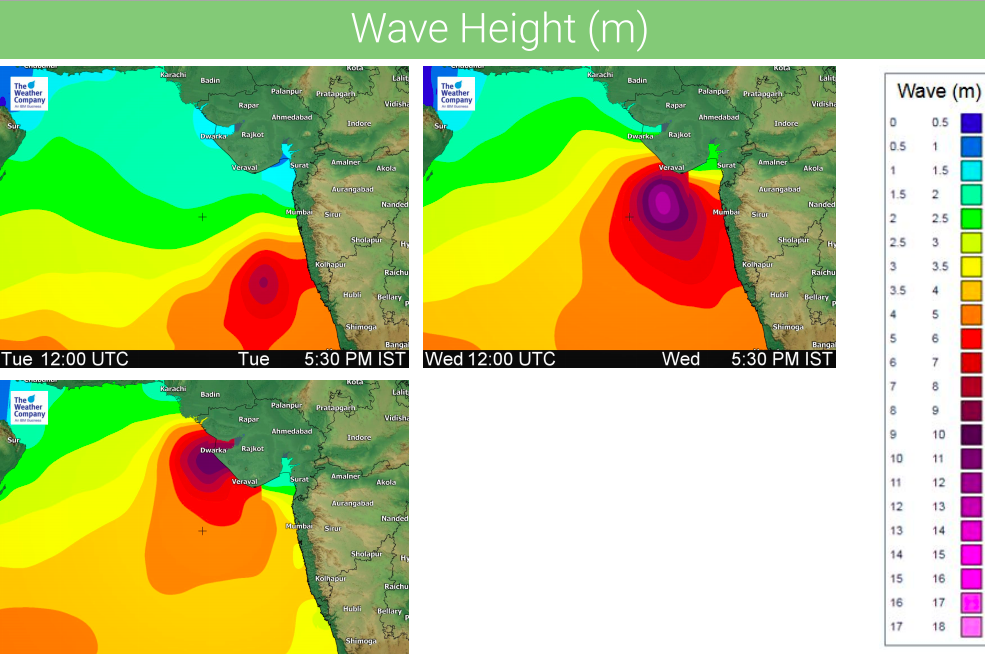
- High waves more than 6 m are forecast along coastal Karnataka, Maharashtra, and Gujarat Tuesday to Thursday.
- The heaviest rainfall until 6:30 am Thursday will be along coastal Kerala, Karnataka, Maharashtra, and Gujarat with accumulation of upto 150 mm locally.
- The expected risks will be heavy rain, thunderstorms, flooding, wind gusts, and rough seas. The risks of downed trees, power outages, and damage to buildings are not ruled out. More attention should be paid to local safety management.


 – 3rd wind map for Thu 5:30 PM IST
 – 3rd map for Thu 5:30 PM IST
– WeatherWatch.co.nz – An official IBM/TWC partner
Comments
Before you add a new comment, take note this story was published on 11 Jun 2019.


Add new comment