INDIA: Cyclone VAYU now ‘severe’, may become ‘extreme’, Mumbai impacted (+9 Maps)
12/06/2019 2:43am

> From the WeatherWatch archives
Vayu has now been classed as a ‘Very Severe Cyclonic System”, or VSCS, and maybe become an “Extreme Severe Cyclonic System”, or ESCS, on Wednesday according to authorities. WeatherWatch.co.nz says that just like other parts of the globe there is an entirely local system in India and Pakistan for tropical storms.
WeatherWatch.co.nz has the latest below on Cyclone VAYU:
- The VSCS will move northward with strengthening its power, and may be upgraded to Extremely Severe Cyclonic Storm (ESCS) at 11:30 IST on Wednesday (12th June 06:00 UTC) off Mumbai.
- Estimated conditions in Mumbai are as follows: Closest Point of Approach (CPA) will be 260km to the west.
- Mumbai Max winds: South East 55 with gust 65 km/h.
- Wave height: 6m on Wednesday 08:30 – Thursday 04:30 IST (12th June 03:00 – 23:00 UTC).
- According to JTWC track forecast, the VSCS can land near Veraval (southern Gujarat) on Thursday before noon (IST).
- The storm is expected to travel northwest parallel to the southwest coast of Gujarat before landfall on Thursday evening (IST).
- Estimated Max Wind at landfall: DESTRUCTUVE East North-East 167 with gust 204 km/h (ENE 90G110kt) at Thursday 11:30 IST.
- IMPACTS
- The expected risks will be heavy rain, thunderstorms, flooding, wind gusts, and rough seas. The risks of downed trees, power outages, and damage to buildings are not ruled out. More attention should be paid to safety management.
- High rough waves (up to 10 m significant wave height) are expected over coastal southern Gujarat on Thursday morning to Thursday evening.
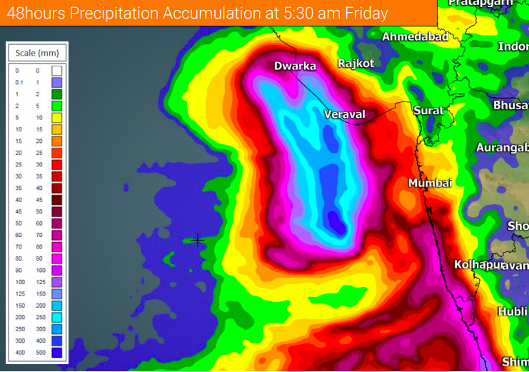
- Up to 200 mm / 48 h accumulated precipitation is partially expected over Gujarat until Friday dawn.


 – Third map Fri 5:30 PM IST
 – Third map map Fri 5:30 PM IST
– WeatherWatch.co.nz
Comments
Before you add a new comment, take note this story was published on 12 Jun 2019.


Add new comment