Increased tropical cyclone potential north of NZ next 14 days (+3 Maps)
10/01/2020 6:35pm

> From the WeatherWatch archives
The tropics north of New Zealand has become quite active in recent days with plenty of rain and downpours forming right across the South West Pacific.
From Tahiti to Rarotonga, Samoa to Fiji, Vanuatu to the Solomon Islands, the active belt of tropical rain and thunderstorms is now enhancing as we head into peak summer. The cyclone season peaks around February and March when oceans are at their warmest, two to three months after the longest day of the year back in late December.
MAIN AREA(S) TO FOCUS ON:
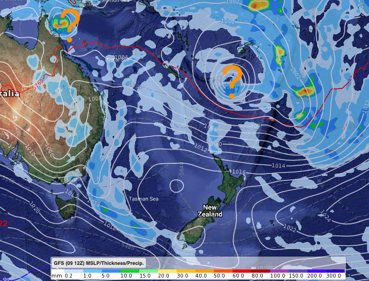
This weekend a low near the Solomons/Vanuatu area will deepen and may become a tropical cyclone next week potentially directly impacting Vanuatu. But, computer modelling is definitely NOT in agreement yet about timing and tracking. Modelling is, however, fairly certain that a number of lows will start spinning in the tropical South West Pacific and Coral Sea areas over the next 14 days.
WILL NZ BE IMPACTED?
GFS modelling out of America (the ones we display on our Maps page – and the same data MetVUW uses) yesterday showed a direct hit next week in NZ – but it’s very important to note that with tropical storms you need at least 3 or 4 days of tracking likely paths and then you need to match that with other modelling to compare. So it’s a fair amount of human forecasting work just to be able to even come to the conclusion we need to write a news story about this – we don’t just see one model showing a storm nearby and go from that, as tomorrow’s update may change it entirely.
ECMWF (out of Europe) shows higher confidence that high pressure in NZ will dominate, holding these lows back away from NZ and bringing us an uptick in summer weather and less rain.
For now there is no direct concern to NZ for any potential cyclone, but those sailing or heading to the tropics for holidays may be keen to track. Also, those with interests or infrastructure in northern NZ who need to monitor any tropical risks.
MAIN FOCUS FOR NOW
Main focus for now remains on concern for storm formation around the Solomon Island, Vanuatu and Fiji areas over the next 7 to 14 days. If you’re in these areas please pay close attention to Government Forecasts for cyclone outlooks in the days to come.
WHICH COMPUTER MODELS DO YOU TRUST IN CYCLONES?
We trust GFS and ECMWF the most, but our IBM data also crunches over 100 weather models to create likely forecasts.
But if you’re trying to track it yourself you may find GFS and ECMWF don’t always line up – when that happens confidence for development of a storm is usually “low” – or at least condidence in tracking of a possible low remains low .
When these two international models line up, that’s when confidence lifts. Weather Forecasters need a series of updates over a number of days to build up confidence in a cyclone forecast – right now it’s too early to lock in details other than saying the right ingredients for tropical storms are now arriving but that high pressure in the NZ area looks (at this early stage anyway) to hold them up in the tropics.
GFS – SAT JAN 18 – Rain and Air Pressure map
ECMWF – SAT JAN 18 – Air Pressure map.
NEXT 7 DAYS RAINFALL COMPARED TO HISTORICAL AVERAGE (US GOVT)
(Red = drier than normal, White = Usual rainfall, Blue = Wetter than average)
– WeatherWatch.co.nz
Comments
Before you add a new comment, take note this story was published on 10 Jan 2020.


Add new comment