> From the WeatherWatch archives
Roads were closed in Otago last night as heavy rain drenched the region, which for the last four months has failed to reach its average rainfall.
The Fire Service attended 40 weather-related incidents overnight, mostly surface flooding and slips in and around Dunedin, but also in Oamaru and as far as Temuka in south Canterbury, southern fire communications shift manager Karl Patterson said.
There were several road closures yesterday and Three Mile Hill remained closed from Mosgiel to Dunedin this morning due to flooding and State Highway 88 from Sawyers Bay to Port Chalmers due to a slip, Senior Sergeant Steve Aitken said.
Metservice forecaster Larissa Marintchenko said the rain had eased this morning and fine breaks should develop later in the day.
The rain was “just the tonic” for the region, which for three months out of the last four had failed to reach its monthly average rainfall, consultant hydrologist Dave Stewart said.
“It’s desperately needed”
The last time the region saw more than 12mm of rain was on May 8, when 54mm was recorded at Musselburgh, Dunedin and 37mm at Dunedin airport. That caused slips, blocked drains, surface flooding and rivers to rise.
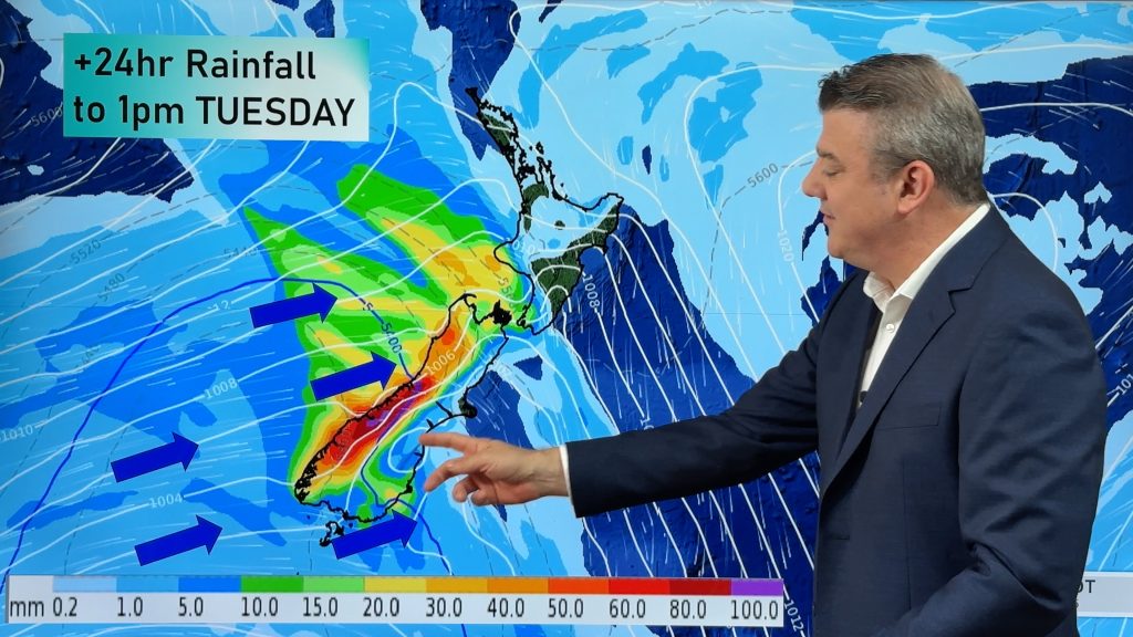
MetService yesterday continued to warn of 100mm to 150mm of rain falling until early this morning, as a southerly front stalled over the South Island.
Rain was predicted to ease and clear this afternoon.
By 9pm yesterday 95mm had fallen at Waitati, 78mm at Oamaru, 60mm at Dunedin airport, 73mm in Dunedin and 30mm at Balclutha.
In the hills around Dunedin in the 24 hours to 3pm, 58mm fell at Sullivans Dam, 42mm at Pine Hill and 81.5mm at Swampy Summit.
However, Wanaka received only 13mm and Queenstown 7mm until 9pm.
As darkness fell last night, Dunedin was starting to feel the full impact of the rain.
Streams of water from a hillside ran around and underneath homes in District Rd, Green Island, and a blocked culvert between Wills St, in Balaclava and Lindsay Rd caused a minor slip that sent water rushing through properties in Lindsay Rd.
A culvert blocked with gorse detritus diverted its contents along Kaka Rd in St Leonards and through the home of an elderly couple.
Surface flooding affected many properties in Mosgiel and around Dunedin.
The Water of Leith reached its first flood warning level of 55cumecs about 8pm.
Mr Stewart said the rain was good news for farmers, who needed the rain for continued grass growth.
While it would cause freshes in the rivers, that was probably a good thing as it “would clean them out a bit”, he said.
“It’s not too heavy, so the ground is soaking up quite a bit. It’s just the tonic for grass growth. Farmland will be soaking it up.”
By early yesterday, the heavy rain had put the head of the Pomahaka River in flood and led to surface flooding on several roads in West Otago, particularly at Kelso, which received 35mm to 3pm yesterday. Flooding closed State Highway 90 between Tapanui and McNab.
Adam McCall, who farms beside the Pomahaka River near Kelso, was alerted by flood warnings at 2.30am yesterday and began shifting dairy cattle.
“The warning was probably a bit premature, as the river didn’t come on the property until 4.30pm. It’s been rising ever since,” he said.
Toko Mouth Rd, near Milton, reopened late afternoon after it was closed because of flooding.
Otago Regional Council flood managers were monitoring river levels and expected them to rise further. The Silver Stream reached 75cumecs (its first flood warning is 40cumecs) at 7.30pm.
Silverstream Valley Rd was closed yesterday by flooding and slips.
The Taieri River at Outram, which was at 129cumecs at 7pm yesterday, was expected to reach its first flood warning level of 195cumecs and the Manuherikia, which was at 56cumecs at 7pm, was also expected to reach its first flood warning of 100cumecs.
The Kakanui River and other North Otago rivers were expected to rise rapidly overnight and reach flood warning levels, the council said.
Waitaki District Council emergency services manager Chris Raine said winds between 60kmh and 70kmh had knocked down “the odd tree” in North Otago, and some minor roads had been closed by surface flooding.
New Zealand Transport Agency was also warning motorists to be aware of high winds on SH87 Outram to Kyeburn, SH1 Pukeuri to Palmerston and SH83 Pukeuri to Omarama.
Heavy snow closed the Lindis Pass last night. The condition of the road will be reassessed this morning.
– Homepage image / File, www.MandenoMoments.com
– APNZ, With the Otago Daily Times
Comments
Before you add a new comment, take note this story was published on 18 Oct 2011.


Add new comment
CHB on 19/10/2011 10:59pm
Over 3 inches fell where we are in Temuka in just under 24hrs! Gully nearly broke its banks. Rather large puddles hidden beneath long grass in paddocks being found. But with all that, you can almost hear the ground sucking up the moisture :o) Yay. So long as the NWs stay away for a few days – mmmm
Reply
Leighton on 18/10/2011 11:25pm
Approaching 50mm here, 47.2mm to be exact at the moment here and very heavy rain falling still. GFS just through plots another 53mm for us but I think thats unrealistic given the radar shows a clearance inside the next 2 hours tops? Flooding on the roads all over the show and the Heathcote river has burst its banks! Photos to follow later if wanted.
Reply
Rachel Jennings on 18/10/2011 10:05pm
Christchurch is going to be soping wet later on. The rain is coming down!!
Reply