> From the WeatherWatch archives
UPDATED
Thunder and hail continues to affect northern and western parts of the North Island with a large hail shower hitting Tauranga and surrounding regions early this afternoon.
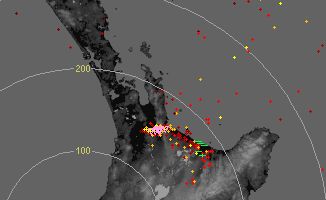
So far today the Lightning Tracker at WeatherWatch.co.nz has detected over 5100 strikes with reports of loud thunder in Taranaki, Matamata, Auckland and Northland today.
More heavy showers are being predicted by WeatherWatch.co.nz this afternoon mainly about Auckland, Waikato, Northland, Taranaki and Bay of Plenty however WeatherWatch believes the risk of thunderstorms is now easing west of the Kaimai Ranges.
Have photos of today’s thunder and hail storms? Upload them easily by clicking here
View the live and free Lightning Tracker
Image left: Lightning Tracker taken around 12:30pm. Image Right: MetService rain radar, red blob in box is hail/thunderstorm.


Images below / Brendan Pratt
Images below / Grayson Ottaway, Classic Hits 95FM Tauranga


Images below / Emma Kapua
Below images: Mike Jones 

Comments
Before you add a new comment, take note this story was published on 29 Aug 2010.


.preview.JPG)


Add new comment