Friday’s forecast – Heavy rain & thunderstorms, but easing for many others
5/01/2023 11:00am

> From the WeatherWatch archives
Various fronts and troughs lie over New Zealand today bringing showers or rain to most regions, heavy falls and possible thunderstorms are in the mix too.
North Island
Rain or showers for most regions with humid conditions, rain from Auckland through to Bay Of Plenty is heavy at times, rain about Auckland starts to ease today. Eastern regions are a little drier overall however south of Napier in the morning has rain then easing back.
Northeasterly winds are strong and gusty for some but easing later today – and aren’t as intense as they’ve been.
South Island
Mostly cloudy with rain or showers for Nelson / Marlborough and down the West Coast. Quite humid. Southland and Otago may have the odd spit in the morning then showers becoming more widespread in the afternoon, some heavy with thunderstorms especially just inland away from the coast. Rain in the south and east up to South Canterbury may become more widespread and heavy from evening. Showers spreading into Canterbury from afternoon. Northeasterly winds for most but southerlies for Southland and up the east coast through to Banks Peninsula.
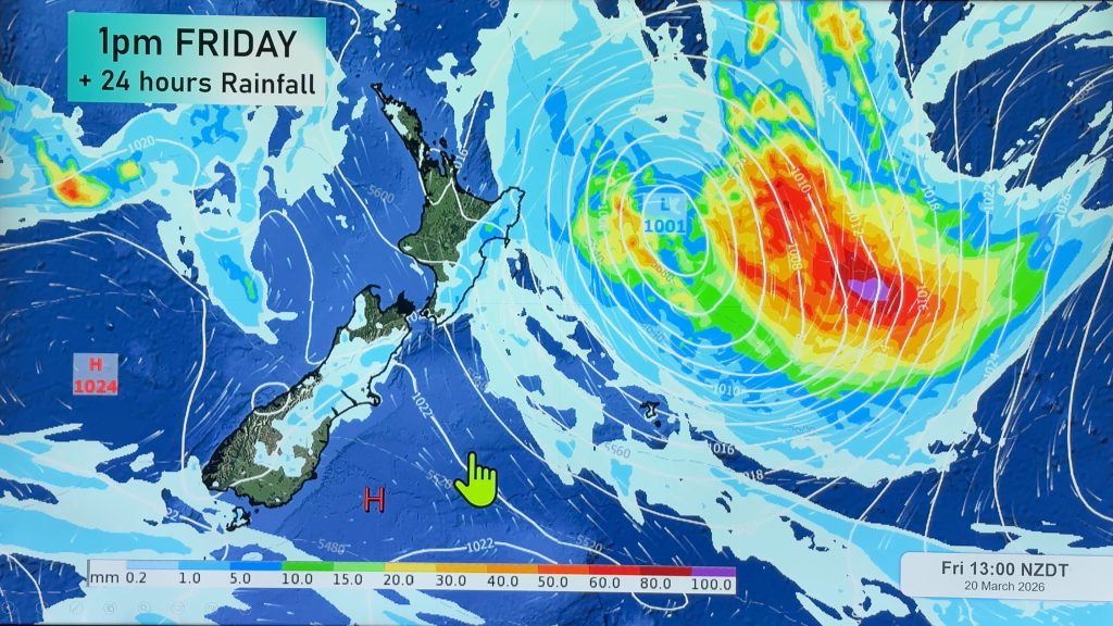
MSLP / Rain map – Fri 6th Jan 2023 4:00pm – Weatherzone.com.au 
Comments
Before you add a new comment, take note this story was published on 5 Jan 2023.
Latest Video

High pressure grows, but a stormy end to next week possible
A settled weekend is on the way and apart from a few isolated showers in both main islands many regions…
Related Articles
High pressure grows, but a stormy end to next week possible
A settled weekend is on the way and apart from a few isolated showers in both main islands many regions…

A tropical low next week *might* affect NZ
It’s not locked in yet, but a tropical storm may end up drifting southwards towards NZ about one week from…
NZ 9 Day: Two subtropical lows, but a lot of dry weather
In our extended outlook today we track two subtropical storms, one that will likely miss most of NZ while the…


Add new comment
Lance on 6/01/2023 8:16am
La Nina at its best. This weather pattern can last for 20yrs .. an has often in the past .. the new norm
Reply