Friday’s national forecast – Heavy rain and low moves away
14/07/2022 12:00pm

> From the WeatherWatch archives
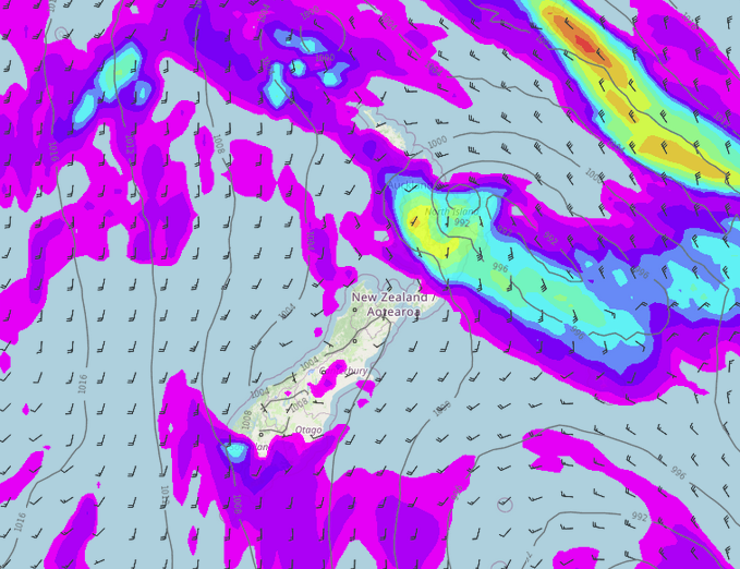
A low bringing heavy rain to the North Island this morning moves away to the east this afternoon, expect a southwesterly airflow further south.
Northland, Auckland, Waikato & Bay Of Plenty
Partly cloudy, the odd shower possible. Morning rain eases to showers then clears in the afternoon for Waikato and Bay Of Plenty. Some rain may pass over Northland in the afternoon. Overnight a few showers move in from the Tasman Sea. Southwesterly winds.
Highs: 13-16
Western North Island (including Central North Island)
Morning rain (snow to 900m about the Central Plateau), possibly heavy first thing then easing and clearing in the afternoon. Showers move back in in the evening as southeasterlies tend northwest.
Highs: 7-13
Eastern North Island
Morning rain, possibly heavy then easing to showers in the afternoon, clearing evening. A few showers may move back into Wairarapa overnight. Fresh southeasterlies tend southwest in the morning, dying out evening.
Highs: 10-14
Wellington
Mostly cloudy with the odd shower, it may dry out for a time in the afternoon. Fresh southerlies.
Highs: 10
Marlborough & Nelson
Partly cloudy, showers move into Nelson late afternoon then Marlborough in the evening. Clearing overnight. Southerlies in the morning, afternoon northerlies for Nelson, afternoon easterlies for Marlborough.
Highs: 10-13
Canterbury
Mostly cloudy, a few showers too mainly Banks Peninsula northwards. Some sun may break through in the afternoon further south after morning showers clear. Snow to 500m, especially evening about inland North Canterbury. Southwesterly winds.
Highs: 1-11
West Coast
Fiordland is sunny, further north expect cloudier skies with showers from afternoon then clearing overnight. Southwesterly winds.
Highs: 7-12
Southland & Otago
Showers with snow flurries to 500m, perhaps lowering to 400m later in the day, clearing Otago overnight. Southwesterly winds.
Highs: 5-8
Comments
Before you add a new comment, take note this story was published on 14 Jul 2022.


Add new comment