Deep tropical low to unravel over New Zealand next week (+4 Maps)
25/01/2018 12:27am

> From the WeatherWatch archives
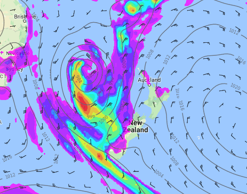
A deep low in the Coral Sea/north Tasman Sea early next week will quickly drop south into the New Zealand area on Wednesday, January 31st, bringing rain to the West Coast then spreading across other parts of the country with a very humid airflow.
According to models the low is likely to significantly change shape and size as it moves into the New Zealand area and may not be a “storm” once it gets here – but could still produce areas of severe weather.
The two main risks at this stage will be heavy rain and possible coastal flooding – as the low and strong northerly quarter winds arrive around the same time as the Super Moon which means higher than usual tides may again coincide with a low pressure system (which can increase high tides anyway), like we saw in early January.
The good news is that – at least at this early stage – the centre of the low will be further west offshore from the North Island. It may also bring in rain to very dry regions like Southland and Otago which will be welcome news to many.
However the system could become messy and new areas of concern may form in the very humid northerly airflow. “It’s possible we may see localised flooding from torrential downpours and some coastal flooding due to higher than usual tides” says WeatherWatch.co.nz head forecaster Philip Duncan. “This area of tropical low pressure should cross New Zealand in the first couple of days of February then will likely be followed by a drier sou’west flow which will bring hot weather back to the eastern North Island but ease the heat in the lower South Island”.
WeatherWatch.co.nz says daytime highs in Central Otago on Monday (two days before the low arrives) could reach the mid to late 30s. But one week from now the daytime high could be more than 15 degrees cooler as a sou’wester arrives after the low dropping afternoon highs into the late teens for some southerners.
Humidity levels could be at 100% next week for a time as tropical moisture crossed the country dragged down by the tropical system. The North Island is expected to be especially muggy with overnight lows potentially not dropping below 22 degrees for some places from Auckland northwards.
 Noon Tuesday
 Noon Wednesday

– Noon Thursday
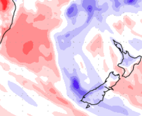
 The next 7 days: Blue = wetter than average, Red = drier than average. White = Average rainfall for late January. / US Government.
– WeatherWatch.co.nz
Comments
Before you add a new comment, take note this story was published on 25 Jan 2018.


Add new comment
Guest on 25/01/2018 3:24am
awesome phil those southern fronts of yours are use less a part from westland
Reply