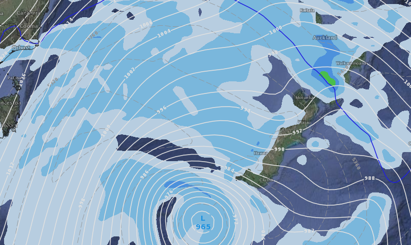
Deep low to cross southern New Zealand on Saturday, colder Sunday for many
7/09/2017 8:15am

> From the WeatherWatch archives
The centre of a very deep low in the Southern Ocean will cross/brush southern New Zealand on Saturday with various computer models agreeing the air pressure will be in the 960 hPa range for a time (deeper air pressure means the low is spinning faster and becoming more powerful).
Both GFS (American) and ECMWF (European) agree the low will bottom out in the low to mid 960 hPa range on Saturday morning at some point – then as it tracks around Stewart Island/Southland area it will start to weaken with the air pressure rising quickly into the 980s by Sunday, as the low lies east of Otago.
“In a nut shell this short lived storm is tracking out of the Southern Ocean area and into the South Pacific, as it tracks towards and crosses the Stewart Island and Southland areas it will weaken quiclkly, partially due to NZ’s landmass, rapidly weakening into Sunday morning” says head forecaster Philip Duncan.
Deep lows from out of the Southern Ocean are normal at this time of the year – and normal to see them quickly fall apart once they run into the strong spring westerlies.
Despite the deep low air pressure, the rapid weakening late Saturday and into Sunday means severe weather isn’t expected to be widespread, but please keep up to date with forecasts. Gales, heavy rain and snow are all possible this weekend as this system tracks past slowly – so too are further thunderstorms with squalls and hail.
The cold change behind this low will be short lived – but wintry with snow on the alpine passes and flurries lowing to a few hundred metres for a time. Sunday and Monday will be colder nationwide but by Tuesday the milder spring westerlies return to the country.
The large size of this low is helping spread the energy further, explaining why it’s blustery for many regions but for most it’s quite a bit below warning levels. Government forecaster MetService may issue tax funded warnings for wind, rain in the coming days, also snow forecsasts for alpine passes so please keep up to date with them too.
Welcome to spring 2017! The westerly winds have arrived early this year! (often they start around the equinox in another two weeks, but each year it varies here).
 GFS model for sunrise Saturday shows the bulk of the worse winds out at sea, but brushing the South Island with heavy rain in the west.
 ECMWF model for before dawn Sunday producing heaving rain on the West Coast and a burst of gales for some areas.
– WeatherWatch.co.nz
Comments
Before you add a new comment, take note this story was published on 7 Sep 2017.


Add new comment