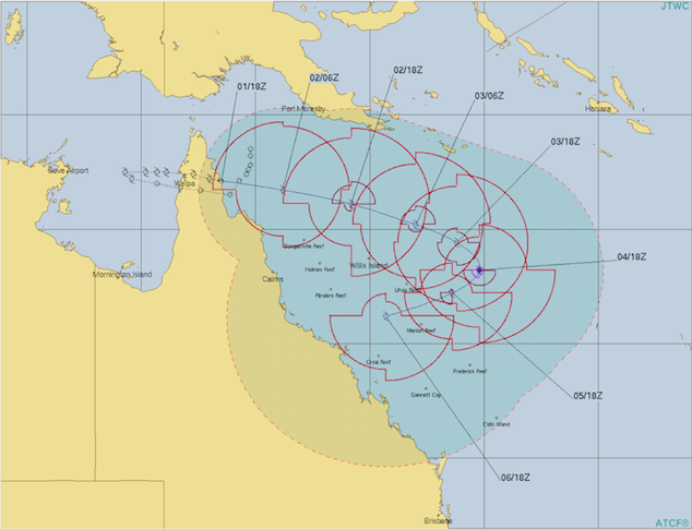
Cyclone Penny could re-form and track back towards Queensland coast, Bureau of Meteorology says
2/01/2019 1:42am

> From the WeatherWatch archives
Ex-tropical cyclone Penny could re-form off Queensland within hours but there is uncertainty about whether it will track back towards the coast, the Bureau of Meteorology (BOM) says.
Penny uprooted trees and flooded roads when it made landfall yesterday afternoon south of Weipa as a category one system.
It is now a tropical low about 60 kilometres offshore of Lockhart River on the Cape York Peninsula, and is moving east-south-east into the Coral Sea.
BOM meteorologist Jess Gardener said it was likely to re-form as a cyclone at sea but it was not clear if it would head back toward the coast.
“It could be as early as this afternoon,” she said.
“We are expecting it to continue moving south-east. It could develop up to a category two.
“There is a lot of uncertainty in the models at the moment but there is definitely a chance it could recurve at the end of the week and start moving south-west and approach the central coast early next week.”
There are still severe weather warnings for heavy rain, damaging winds and abnormally high tides for the Northern Peninsula Area, Torres Strait Islands and parts of eastern Cape York.
Weipa Town Authority chairman Michael Rowland said while conditions had eased in his area, roads remained cut throughout the region.
“We have heard instances there are some people currently waiting to cross one of the larger river systems, the Archer River, so they’ve been isolated and they’re sort of stuck there at a little roadhouse. People trying to get back from Christmas.”
Far Northern SES regional director Wayne Coutts said communities in the cyclone’s path held up well.
“Just a lot of vegetation damage as you’d expect from a category one, fairly limited structural damage just basically caused by a few trees that lent over onto buildings and that sort of thing,” he said.
“In these remote communities people are very well prepared for the cyclone season.”
Mr Coutts said the SES only received two calls for help, both for leaking roofs, overnight in Weipa.
“That’s excellent, that’s a testament I guess to people being able to help themselves and being well prepared,” he said.
Yesterday’s cyclone brought more than 100 millimetres of rain to several areas in the far north.
Scherger RAAF Base received 121 millimetres since 9:00am yesterday, with 63 millimetres falling between 6:00pm and 9:00pm.
Moreton recorded 118 millimetres, while Cohen received 116 millimetres.

Image: Joint Typhoon Warning Centre latest graphic on TC Penny – http://www.metoc.navy.mil/jtwc/jtwc.html
Story by Talissa Siganto and Nick Wiggins – ABC / weatherzone.com.au
Comments
Before you add a new comment, take note this story was published on 2 Jan 2019.


Add new comment