Cyclone Gita: Latest possible tracking into NZ next week (+6 Maps)
14/02/2018 11:52pm

> From the WeatherWatch archives
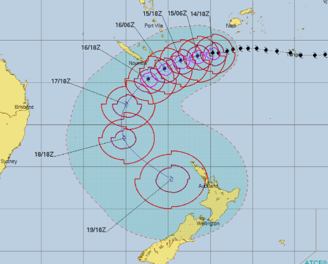
Severe Cyclone Gita remains a Category 4 cyclone this morning 1700kms directly north of Auckland, New Zealand. The cyclone is tracking westwards at 13km/h and will start to track more WSW in the coming 24 hours, before turning more southerly this weekend in the Tasman Sea.
Gita is out over open waters in favourable conditions to retain strength and will hold at Category 4 or a strong Cat 3 storm over the next couple of days and weekend, based on numerous modelling.
The Fiji Met Service says it has central air pressure of 950hPa, up from 927hPa on Wednesday morning.
Models are still in agreement that the centre of Gita will hit the western side of the New Zealand next week, most likely the western side of the North Island. However they are still on different pages about when it comes to timing. Gita could arrive in New Zealand as early as Monday night and as late as Thursday morning.
Most models do agree Tuesday and Wednesday will be the likely time that Gita hits New Zealand.
Gita may also combine with a southerly to produce extra heavy rain where the tropical northerlies and cooler southerlies converge. Flooding risks could be increased due to this in the upper South Island and lower North Island. While Gita will become an extra-tropical cyclone once it moves into New Zealand it may still retain Category 2 or 1 strength winds, which means powercuts and some wind damage is possible – but the storm is too far out from reaching us to be able to lock in any specific severe weather risks at this early stage.
Most long range forecasts agree it should be gone by next Friday though (8 days from now). WeatherWatch.co.nz aims to fine tune this forecast even more so on Friday and Saturday.
 – Forecast tracking and ‘cone of uncertainty’ by JTWC (US Government)
 – Gita’s history and future / Fiji Met Service
 – Gita may track halfway between Norfolk Island and Noumea, New Caledonia – if this happens it will spare both places significant damage, but is very close to be brushed by such a powerful storm. Residents in both places need to be up to date with forecasts and modelling as this may change as the storm gets closer. Fiji Met Service.
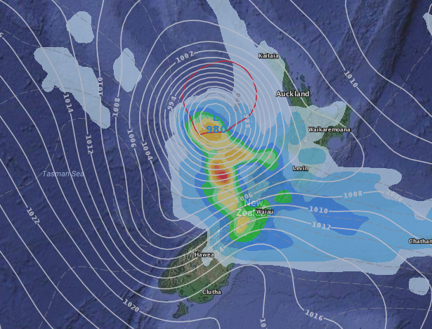
GFS – TUESDAY PM
ECMWF – TUESDAY PM
 – Colourised satellite map / Himawari and NOAA (Japanese and US Governments)
– WeatherWatch.co.nz
Comments
Before you add a new comment, take note this story was published on 14 Feb 2018.


Add new comment
Dave on 15/02/2018 6:03pm
We are landing in Auckland on Sunday for a family North Island holiday. I’m thinking of adjusting our plans and hunkering down in Auckland for the beginning of the week. Any recommendations?
Reply
WW Forecast Team on 15/02/2018 9:19pm
Hi there
Best bet is to use these rain maps here – http://www.weatherwatch.co.nz/forecast-maps/rain
Scroll through the various times / days and you’ll be able to see where showers or areas of rain are, what days are dry etc 🙂
Hope that helps!
Cheers
Aaron
Reply
View more comments